IMAGES TAKEN NEAR TO
Elder Tree Lane, MARKET DRAYTON, TF9 4NE
Introduction
This page details the photographs taken nearby to Elder Tree Lane, TF9 4NE by members of the Geograph project.
The Geograph project started in 2005 with the aim of publishing, organising and preserving representative images for every square kilometre of Great Britain, Ireland and the Isle of Man.

There are currently over 7.5m images from over14,400 individuals and you can help contribute to the project by visiting https://www.geograph.org.uk
Image Map
Images are licensed for reuse under creativecommons.org/licenses/by-sa/2.0
Notes
- Clicking on the map will re-center to the selected point.
- The higher the marker number, the further away the image location is from the centre of the postcode.
Image Listing (10 Images Found)
Images are licensed for reuse under creativecommons.org/licenses/by-sa/2.0
Image
Details
Distance
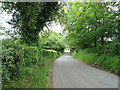
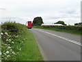
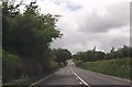
4
Bend on A53 approaching Park Lane junction
Image: © John Firth
Taken: 15 Jun 2013
0.12 miles
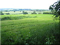
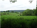
7
Crop field near Holly Croft Farm
Off Newcastle Road (A53).
Image: © JThomas
Taken: 1 Jun 2019
0.20 miles
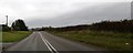
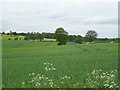
8
Church Lane, Ashley
Looking north from Wharmadine Lane towards the junction with Eldertree Lane.
Image: © Jonathan Billinger
Taken: 6 Sep 2016
0.21 miles
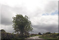
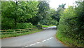
10
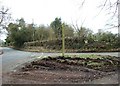
The Newcastle Way
The waymark for this footpath sits slightly uneasily on a small traffic island.
Image: © Simon Huguet
Taken: 28 Feb 2009
0.23 miles