IMAGES TAKEN NEAR TO
Elder Tree Lane, MARKET DRAYTON, TF9 4LX
Introduction
This page details the photographs taken nearby to Elder Tree Lane, TF9 4LX by members of the Geograph project.
The Geograph project started in 2005 with the aim of publishing, organising and preserving representative images for every square kilometre of Great Britain, Ireland and the Isle of Man.

There are currently over 7.5m images from over14,400 individuals and you can help contribute to the project by visiting https://www.geograph.org.uk
Image Map (Loading...)


Getting Data...Please wait
Leaflet Map data © OpenStreetMap
Images are licensed for reuse under creativecommons.org/licenses/by-sa/2.0
Notes
- Clicking on the map will re-center to the selected point.
- The higher the marker number, the further away the image location is from the centre of the postcode.
Image Listing (12 Images Found)
Images are licensed for reuse under creativecommons.org/licenses/by-sa/2.0
Image
Details
Distance
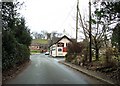
1
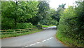
Church Lane, Ashley
Looking north from Wharmadine Lane towards the junction with Eldertree Lane.
Image: © Jonathan Billinger
Taken: 6 Sep 2016
0.06 miles
2
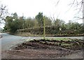
The Newcastle Way
The waymark for this footpath sits slightly uneasily on a small traffic island.
Image: © Simon Huguet
Taken: 28 Feb 2009
0.07 miles
3
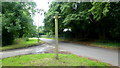
Footpath sign at a road junction
Where Wharmamdine Lane meets Church Lane, Ashley.
Image: © Jonathan Billinger
Taken: 6 Sep 2016
0.08 miles
5
Church Road
Church, pub, bus stop and public telephone box. Pretty much all a village needs encapsulated in one picture.
Image: © Simon Huguet
Taken: 28 Feb 2009
0.17 miles
6
Ashley Congregational Chapel
Built 1841
Image: © Brian Deegan
Taken: 25 Jul 2021
0.17 miles
7
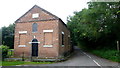
Ashley Congregational Chapel
Over nine years have elapsed since the First Geograph for this square was taken, Image, and the scene has not changed much. The chapel appears to be disused.
Image: © Jonathan Billinger
Taken: 6 Sep 2016
0.18 miles
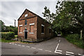
9
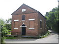
Ashley: Congregational Chapel
The Chapel was built in 1841 and it at the junction of Chapel Lane, going up the hill to the right, and School Lane crossing from left to right in the foreground.
Image: © Nigel Cox
Taken: 15 Jun 2007
0.20 miles
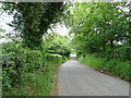
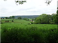
10
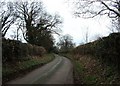
Wharmadine Lane
Looking towards Ashley, the drive to Ashley Grange Farm is in the trees to the left hand side.
Image: © Simon Huguet
Taken: 28 Feb 2009
0.21 miles