IMAGES TAKEN NEAR TO
Pipe Gate, MARKET DRAYTON, TF9 4HU
Introduction
This page details the photographs taken nearby to TF9 4HU by members of the Geograph project.
The Geograph project started in 2005 with the aim of publishing, organising and preserving representative images for every square kilometre of Great Britain, Ireland and the Isle of Man.

There are currently over 7.5m images from over14,400 individuals and you can help contribute to the project by visiting https://www.geograph.org.uk
Image Map (Loading...)


Getting Data...Please wait
Leaflet Map data © OpenStreetMap
Images are licensed for reuse under creativecommons.org/licenses/by-sa/2.0
Notes
- Clicking on the map will re-center to the selected point.
- The higher the marker number, the further away the image location is from the centre of the postcode.
Image Listing (7 Images Found)
Images are licensed for reuse under creativecommons.org/licenses/by-sa/2.0
Image
Details
Distance
2
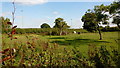
Paddock with old orchard trees
In the triangle of land between the A51 and the B5026
Image: © Jonathan Billinger
Taken: 5 Sep 2018
0.17 miles
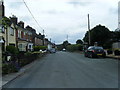
5
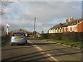
Irelands Cross
Cross roads on the A51
Image: © Peter Fleming
Taken: 20 Aug 2007
0.20 miles
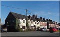
6
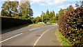
Ireland's Cross
The junction of the B5026 with the A51.
Image: © Jonathan Billinger
Taken: 5 Sep 2018
0.20 miles
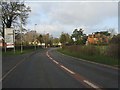
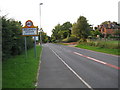
7
Pipe Gate with short A51 by-pass on right
Image: © Colin Pyle
Taken: 10 Jul 2010
0.22 miles