IMAGES TAKEN NEAR TO
Smithy Lane, MARKET DRAYTON, TF9 4HP
Introduction
This page details the photographs taken nearby to Smithy Lane, TF9 4HP by members of the Geograph project.
The Geograph project started in 2005 with the aim of publishing, organising and preserving representative images for every square kilometre of Great Britain, Ireland and the Isle of Man.

There are currently over 7.5m images from over14,400 individuals and you can help contribute to the project by visiting https://www.geograph.org.uk
Image Map (Loading...)


Getting Data...Please wait
Leaflet Map data © OpenStreetMap
Images are licensed for reuse under creativecommons.org/licenses/by-sa/2.0
Notes
- Clicking on the map will re-center to the selected point.
- The higher the marker number, the further away the image location is from the centre of the postcode.
Image Listing (5 Images Found)
Images are licensed for reuse under creativecommons.org/licenses/by-sa/2.0
Image
Details
Distance
1
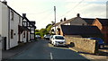
Smithy Lane, Knighton
The same street as that photographed over 13 years ago, with no other photo uploaded for this square in between.
See Image
Image: © Jonathan Billinger
Taken: 5 Sep 2018
0.04 miles
2

Old Milepost by the B5026, London Road, Knighton
Cast iron post by the B5026, in parish of LOGGERHEADS (NEWCASTLE UNDER LYME District), London Road, Knighton, on grass verge in front of garden wall, on East side of road. Lathe iron casting, erected by the County Council in the 19th/20th century.
Inscription reads:-
: ECCLESHALL 11 / STAFFORD 18 : : KNIGHTON : : WOORE 1¼ / NANTWICH 9¼ :
Maker:-
: Chas. Lathe, Tipton. :
Grade II listed.
List Entry Number: 1377622 https://historicengland.org.uk/listing/the-list/list-entry/1377622
Milestone Society National ID: ST_STNW18.
Image: © J Higgins
Taken: 1 Jan 2001
0.14 miles
3

London Road (B5026) at Knighton
Looking north east.
Image: © JThomas
Taken: 1 Jun 2019
0.15 miles