IMAGES TAKEN NEAR TO
Bearstone, MARKET DRAYTON, TF9 4HG
Introduction
This page details the photographs taken nearby to TF9 4HG by members of the Geograph project.
The Geograph project started in 2005 with the aim of publishing, organising and preserving representative images for every square kilometre of Great Britain, Ireland and the Isle of Man.

There are currently over 7.5m images from over14,400 individuals and you can help contribute to the project by visiting https://www.geograph.org.uk
Image Map (Loading...)


Getting Data...Please wait
Leaflet Map data © OpenStreetMap
Images are licensed for reuse under creativecommons.org/licenses/by-sa/2.0
Notes
- Clicking on the map will re-center to the selected point.
- The higher the marker number, the further away the image location is from the centre of the postcode.
Image Listing (9 Images Found)
Images are licensed for reuse under creativecommons.org/licenses/by-sa/2.0
Image
Details
Distance
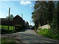
1
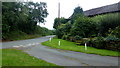
Lane junction at Bearstone
The building to the right is part of Bearstone Farm.
Image: © Jonathan Billinger
Taken: 6 Sep 2016
0.10 miles
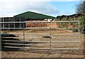
2
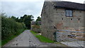
Stone buildings at Bearstone Farm
Possibly a conversion project in the future?
Image: © Jonathan Billinger
Taken: 6 Sep 2016
0.11 miles
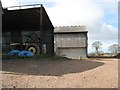
5
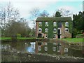
Bearstone Mill
Old water driven mill.
Image: © Andy and Hilary
Taken: 16 Apr 2005
0.14 miles
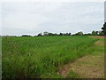
8
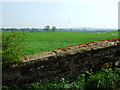
Farmland on the line of the railway
East of the bridge no trace of the railway now exists except for a slight depression in the farmland.
Image: © John Poyser
Taken: 8 May 2008
0.23 miles