IMAGES TAKEN NEAR TO
Landmark Close, TF9 4FR
Introduction
This page details the photographs taken nearby to Landmark Close, TF9 4FR by members of the Geograph project.
The Geograph project started in 2005 with the aim of publishing, organising and preserving representative images for every square kilometre of Great Britain, Ireland and the Isle of Man.

There are currently over 7.5m images from over14,400 individuals and you can help contribute to the project by visiting https://www.geograph.org.uk
Image Map (Loading...)


Getting Data...Please wait
Leaflet Map data © OpenStreetMap
Images are licensed for reuse under creativecommons.org/licenses/by-sa/2.0
Notes
- Clicking on the map will re-center to the selected point.
- The higher the marker number, the further away the image location is from the centre of the postcode.
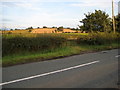
Image Listing (5 Images Found)
Images are licensed for reuse under creativecommons.org/licenses/by-sa/2.0
Image
Details
Distance
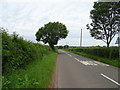
1
Willoughbridge Lane
Looking north-east past Winnington House behind the trees to the left.
Image: © Jonathan Billinger
Taken: 6 Sep 2016
0.04 miles
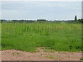
2
Winnington
Looking over the fields towards Winnington from south of Bearstone Mill
Image: © Peter Fleming
Taken: 20 Aug 2007
0.08 miles
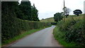
3
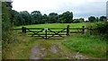
Gate and paddock at Winnington
Private sign stating the obvious.
Image: © Jonathan Billinger
Taken: 6 Sep 2016
0.08 miles