IMAGES TAKEN NEAR TO
Lordsley Lane, MARKET DRAYTON, TF9 4EQ
Introduction
This page details the photographs taken nearby to Lordsley Lane, TF9 4EQ by members of the Geograph project.
The Geograph project started in 2005 with the aim of publishing, organising and preserving representative images for every square kilometre of Great Britain, Ireland and the Isle of Man.

There are currently over 7.5m images from over14,400 individuals and you can help contribute to the project by visiting https://www.geograph.org.uk
Image Map (Loading...)


Getting Data...Please wait
Leaflet Map data © OpenStreetMap
Images are licensed for reuse under creativecommons.org/licenses/by-sa/2.0
Notes
- Clicking on the map will re-center to the selected point.
- The higher the marker number, the further away the image location is from the centre of the postcode.
Image Listing (3 Images Found)
Images are licensed for reuse under creativecommons.org/licenses/by-sa/2.0
Image
Details
Distance
1
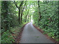
Lordsley: Lordsley Lane
The view looking down the hill towards Lordsley End Farm
Image: © Nigel Cox
Taken: 15 Jun 2007
0.12 miles
2

View to the Maer Hills
West Staffordshire countryside seen from Manor Hill.
Manor House farm can be seen to the left.
Image: © Jonathan Billinger
Taken: 6 Sep 2016
0.17 miles
3
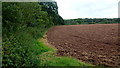
Farmland at Lordsley End
The Forty Acres Wood in the distance.
Image: © Jonathan Billinger
Taken: 6 Sep 2016
0.24 miles