IMAGES TAKEN NEAR TO
Mount Pleasant, MARKET DRAYTON, TF9 4EE
Introduction
This page details the photographs taken nearby to Mount Pleasant, TF9 4EE by members of the Geograph project.
The Geograph project started in 2005 with the aim of publishing, organising and preserving representative images for every square kilometre of Great Britain, Ireland and the Isle of Man.

There are currently over 7.5m images from over14,400 individuals and you can help contribute to the project by visiting https://www.geograph.org.uk
Image Map
Images are licensed for reuse under creativecommons.org/licenses/by-sa/2.0
Notes
- Clicking on the map will re-center to the selected point.
- The higher the marker number, the further away the image location is from the centre of the postcode.
Image Listing (9 Images Found)
Images are licensed for reuse under creativecommons.org/licenses/by-sa/2.0
Image
Details
Distance
2
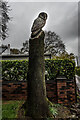
Wood Carved Owl, Ashley Heath
Wood Carving at the side of the road.
Image: © Brian Deegan
Taken: 8 May 2021
0.16 miles
3
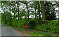
Elizabeth II postbox on Mucklestone Wood Lane, Loggerheads
Postbox No. TF9 463.
See Image] for close up.
Image: © JThomas
Taken: 1 Jun 2019
0.17 miles
4
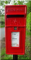
Close up, Elizabeth II postbox on Mucklestone Wood Lane, Loggerheads
Postbox No. TF9 463.
See Image] for wider view.
Image: © JThomas
Taken: 1 Jun 2019
0.17 miles
6
Queen Victoria (VR) Post Box (1837-1901), Ashley Heath
Disused as there is a modern one across the road.
Image: © Brian Deegan
Taken: 8 May 2021
0.18 miles
7
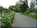
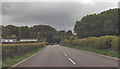
Mucklestone Wood Lane, Loggerheads
Looking south east.
Image: © JThomas
Taken: 1 Jun 2019
0.19 miles
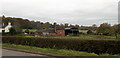
8
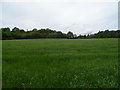
Grassland north of Mucklestone Wood Lane, Loggerheads
Image: © JThomas
Taken: 1 Jun 2019
0.21 miles