IMAGES TAKEN NEAR TO
Bearstone Road, MARKET DRAYTON, TF9 4AR
Introduction
This page details the photographs taken nearby to Bearstone Road, TF9 4AR by members of the Geograph project.
The Geograph project started in 2005 with the aim of publishing, organising and preserving representative images for every square kilometre of Great Britain, Ireland and the Isle of Man.

There are currently over 7.5m images from over14,400 individuals and you can help contribute to the project by visiting https://www.geograph.org.uk
Image Map (Loading...)


Getting Data...Please wait
Leaflet Map data © OpenStreetMap
Images are licensed for reuse under creativecommons.org/licenses/by-sa/2.0
Notes
- Clicking on the map will re-center to the selected point.
- The higher the marker number, the further away the image location is from the centre of the postcode.
Image Listing (4 Images Found)
Images are licensed for reuse under creativecommons.org/licenses/by-sa/2.0
Image
Details
Distance
1
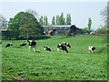
Cattle grazing
Cattle grazing at Bellaport Old Hall farm.
Image: © John Poyser
Taken: 8 May 2008
0.03 miles
2
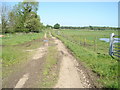
Footpath on track
This track is marked as a footpath on the OS map. Grove Farm is off to the right.
Image: © Brownfox
Taken: 24 May 2009
0.17 miles
3
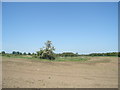
Dewpond near Grove Farm
This artificial pond acts as a haven for plant and animal life, including the large hawthorn (Crataegus monogyna) in flower here.
Image: © Brownfox
Taken: 24 May 2009
0.22 miles
4
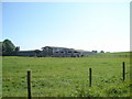
The Grove Farm
This is a mixed farm, growing crops and raising dairy cattle (also visible)
Image: © Brownfox
Taken: 24 May 2009
0.24 miles