IMAGES TAKEN NEAR TO
Oakley, MARKET DRAYTON, TF9 4AQ
Introduction
This page details the photographs taken nearby to TF9 4AQ by members of the Geograph project.
The Geograph project started in 2005 with the aim of publishing, organising and preserving representative images for every square kilometre of Great Britain, Ireland and the Isle of Man.

There are currently over 7.5m images from over14,400 individuals and you can help contribute to the project by visiting https://www.geograph.org.uk
Image Map (Loading...)


Getting Data...Please wait
Leaflet Map data © OpenStreetMap
Images are licensed for reuse under creativecommons.org/licenses/by-sa/2.0
Notes
- Clicking on the map will re-center to the selected point.
- The higher the marker number, the further away the image location is from the centre of the postcode.
Image Listing (6 Images Found)
Images are licensed for reuse under creativecommons.org/licenses/by-sa/2.0
Image
Details
Distance
1
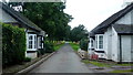
Mucklestone Lodges
Situated at the entrance to Oakley Park, at the end of the public road.
Image: © Jonathan Billinger
Taken: 6 Sep 2016
0.01 miles
2
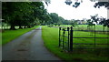
Estate road to The Arbour
Part of Oakley Park.
Image: © Jonathan Billinger
Taken: 6 Sep 2016
0.04 miles
3
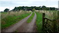
Track to Arbour Cottage
North from the dead-end lane to Oakley Park.
Image: © Jonathan Billinger
Taken: 6 Sep 2016
0.23 miles
4
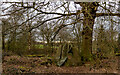
Devils Ring and Finger, Norton in Hales
The monument includes two stones to the south-east of Norton in Hales situated on a gentle slope running down to the River Tern. The stones stand adjacent to each other at the edge of a field boundary. The northern stone is grooved and measures 1.8m high and 1m by 0.6m wide. The southern stone is holed and measures 1.5m high and 1.9m by 0.5m wide. The aperture in the holed stone is 0.45m in diameter and large enough for a person to pass through. There is no evidence to confirm they are in their original position and their leaning nature against a field boundary wall indicates they have been moved. They are likely to be from a chambered tomb or stone setting. There are currently no known associated monuments of the Neolithic and Bronze Age periods within the vicinity, however, the site of a possible Bronze Age disc barrow lies 350m to the south-west.
https://historicengland.org.uk/listing/the-list/list-entry/1003495
Image: © Brian Deegan
Taken: 27 Mar 2021
0.23 miles
5
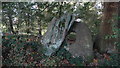
Devil's Ring & Finger near Norton in Hales
This antiquity is not quite on the path but is believed to have been moved to this field boundary some centuries ago.
Image: © Colin Park
Taken: 12 Oct 2017
0.23 miles
6
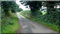
Lane to Mucklestone
Looking east, away from Oakley Park.
Image: © Jonathan Billinger
Taken: 6 Sep 2016
0.24 miles