IMAGES TAKEN NEAR TO
Adderley, MARKET DRAYTON, TF9 3TE
Introduction
This page details the photographs taken nearby to TF9 3TE by members of the Geograph project.
The Geograph project started in 2005 with the aim of publishing, organising and preserving representative images for every square kilometre of Great Britain, Ireland and the Isle of Man.

There are currently over 7.5m images from over14,400 individuals and you can help contribute to the project by visiting https://www.geograph.org.uk
Image Map
Images are licensed for reuse under creativecommons.org/licenses/by-sa/2.0
Notes
- Clicking on the map will re-center to the selected point.
- The higher the marker number, the further away the image location is from the centre of the postcode.
Image Listing (8 Images Found)
Images are licensed for reuse under creativecommons.org/licenses/by-sa/2.0
Image
Details
Distance
1
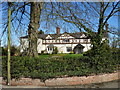
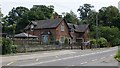
Raven House
Raven House was used as an Auxiliary Hospital during the Great War providing beds for six patients.
Image: © John M
Taken: 5 Apr 2018
0.20 miles
4
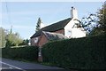
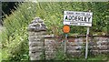
Old Toll House, Adderley
Toll Cottage by the A529, in the parish of Adderley.
To be surveyed
Milestone Society National ID: SA.ADD
Image: © Milestone Society
Taken: Unknown
0.21 miles
5
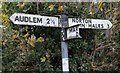
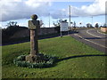
Direction Sign - Signpost by the A529, Adderley
Lost finial - 3 arms; by the A529, in parish of Adderley (North Shropshire District), junction of the A529 with Green Bank, on pavement, against hedge.
Surveyed
Milestone Society National ID: SA_SJ6640
Image: © Milestone Society
Taken: Unknown
0.22 miles
6
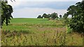
Fodder maize, Adderley
View northwards from a driveway to Adderley Hall, opposite the school.
Image: © Richard Webb
Taken: 2 Jul 2014
0.23 miles