IMAGES TAKEN NEAR TO
Adderley Road, MARKET DRAYTON, TF9 3SW
Introduction
This page details the photographs taken nearby to Adderley Road, TF9 3SW by members of the Geograph project.
The Geograph project started in 2005 with the aim of publishing, organising and preserving representative images for every square kilometre of Great Britain, Ireland and the Isle of Man.

There are currently over 7.5m images from over14,400 individuals and you can help contribute to the project by visiting https://www.geograph.org.uk
Image Map
Images are licensed for reuse under creativecommons.org/licenses/by-sa/2.0
Notes
- Clicking on the map will re-center to the selected point.
- The higher the marker number, the further away the image location is from the centre of the postcode.
Image Listing (8 Images Found)
Images are licensed for reuse under creativecommons.org/licenses/by-sa/2.0
Image
Details
Distance
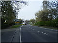
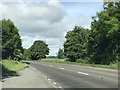
4
Adderley Road (A529) approaching roundabout
On the outskirts of Market Drayton.
Image: © JThomas
Taken: 1 Jun 2019
0.09 miles
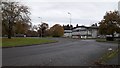
5
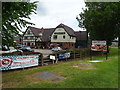
The Gingerbread Man, Market Drayton
Modern Pub & Carvery on Adderley Road.
Image: © JThomas
Taken: 1 Jun 2019
0.10 miles
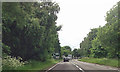
6
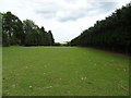
Field off Adderley Road (A529)
Sheep were huddled out of shot in a corner.
Image: © JThomas
Taken: 1 Jun 2019
0.12 miles
8
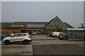
Morrison's supermarket, Cheshire Street, Market Drayton
Image: © Christopher Hilton
Taken: 1 Nov 2015
0.24 miles