IMAGES TAKEN NEAR TO
Spoonley, MARKET DRAYTON, TF9 3SS
Introduction
This page details the photographs taken nearby to TF9 3SS by members of the Geograph project.
The Geograph project started in 2005 with the aim of publishing, organising and preserving representative images for every square kilometre of Great Britain, Ireland and the Isle of Man.

There are currently over 7.5m images from over14,400 individuals and you can help contribute to the project by visiting https://www.geograph.org.uk
Image Map
Images are licensed for reuse under creativecommons.org/licenses/by-sa/2.0
Notes
- Clicking on the map will re-center to the selected point.
- The higher the marker number, the further away the image location is from the centre of the postcode.
Image Listing (12 Images Found)
Images are licensed for reuse under creativecommons.org/licenses/by-sa/2.0
Image
Details
Distance
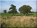
1
Sheep at Springs Farm
Sheep in the field adjacent to Springs Farm
Image: © Peter Fleming
Taken: 11 Oct 2007
0.03 miles
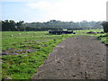
2
Trees in farmland opposite Springs Farm
Trees in field opposite Springs Farm on the A529
Image: © Peter Fleming
Taken: 11 Oct 2007
0.13 miles
3
Shropshire Union Canal milepost at Brownhills Wood
Nantwich 11 miles.
Autherley Junction 28 miles.
Norbury Junction 12½ miles.
Image, for a closer view of the milepost.
Image: © Mat Fascione
Taken: 5 Jul 2019
0.20 miles
4
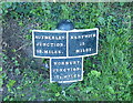
Shropshire Union Canal milepost at Brownhills Wood
Nantwich 11 miles.
Autherley Junction 28 miles.
Norbury Junction 12½ miles.
Image, for a wider view of the milepost.
Image: © Mat Fascione
Taken: 5 Jul 2019
0.20 miles
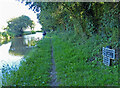
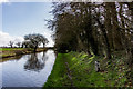
5
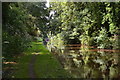
Shropshire Union Canal
In Brownhills Wood.
Image: © Andrew Abbott
Taken: 11 Sep 2022
0.20 miles
7
Shropshire Union Canal
North of Market Drayton.
Image: © Andrew Abbott
Taken: 11 Sep 2022
0.22 miles
8
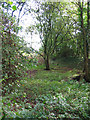
Bed of dismantled railway, Brownhills Wood
Two dismantled railway lines run northwards from Market Drayton; this shows the one that runs NNW towards Adderley, at the edge of Brownhills Wood. Despite the incursion of trees, the line of the former railway is obvious, with a flattened area lined with banks
Image: © Espresso Addict
Taken: 8 Oct 2006
0.23 miles
9
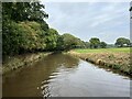
Fallen Tree and Mile Marker 28-11, Shropshire Union Canal
Little bit of storm damage and Mile Marker 28-11
The Shropshire Union main line was the last trunk narrow canal route to be built in England. It was not completed until 1835 and was the last major civil engineering accomplishment of Thomas Telford.
https://en.wikipedia.org/wiki/Shropshire_Union_Canal
https://canalrivertrust.org.uk/enjoy-the-waterways/canal-and-river-network/shropshire-union-canal
Image: © Brian Deegan
Taken: 1 Mar 2020
0.23 miles
10
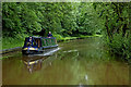
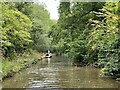
Cruising on the Shroppie
The Shropshire Union Canal is very popular for leisure cruising, despite its clusters of locks. This image of the canal is north of Market Drayton. The beautifully painted narrowboat "Eleanor Rose" is approaching from the direction of Audlem. A dismantled railway is in the trees at the top of the embankment on the left.
Image: © Roger Kidd
Taken: 5 Jun 2018
0.23 miles