IMAGES TAKEN NEAR TO
Oldfields, MARKET DRAYTON, TF9 3RW
Introduction
This page details the photographs taken nearby to TF9 3RW by members of the Geograph project.
The Geograph project started in 2005 with the aim of publishing, organising and preserving representative images for every square kilometre of Great Britain, Ireland and the Isle of Man.

There are currently over 7.5m images from over14,400 individuals and you can help contribute to the project by visiting https://www.geograph.org.uk
Image Map (Loading...)


Getting Data...Please wait
Leaflet Map data © OpenStreetMap
Images are licensed for reuse under creativecommons.org/licenses/by-sa/2.0
Notes
- Clicking on the map will re-center to the selected point.
- The higher the marker number, the further away the image location is from the centre of the postcode.
Image Listing (7 Images Found)
Images are licensed for reuse under creativecommons.org/licenses/by-sa/2.0
Image
Details
Distance
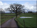
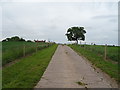
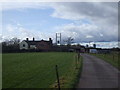
5
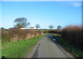
Moreton Say lane on a winter afternoon
View NNE along the narrow single-track lane between Newstreet Lane and Moreton Say, just south of the Oldfields farmtrack. The flooded ditch visible on the left marks the start of an unnamed brook which flows southwards into Image The two semi-detached houses on the horizon are Oaklands
Image: © Espresso Addict
Taken: 20 Jan 2007
0.20 miles
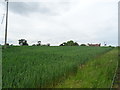
6
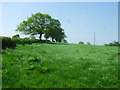
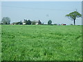
Field of grass
One of the fields next to Oldfields farm.
Image: © John Poyser
Taken: 8 May 2008
0.21 miles