IMAGES TAKEN NEAR TO
The Avenue, MARKET DRAYTON, TF9 3JL
Introduction
This page details the photographs taken nearby to The Avenue, TF9 3JL by members of the Geograph project.
The Geograph project started in 2005 with the aim of publishing, organising and preserving representative images for every square kilometre of Great Britain, Ireland and the Isle of Man.

There are currently over 7.5m images from over14,400 individuals and you can help contribute to the project by visiting https://www.geograph.org.uk
Image Map
Images are licensed for reuse under creativecommons.org/licenses/by-sa/2.0
Notes
- Clicking on the map will re-center to the selected point.
- The higher the marker number, the further away the image location is from the centre of the postcode.
Image Listing (4 Images Found)
Images are licensed for reuse under creativecommons.org/licenses/by-sa/2.0
Image
Details
Distance
1
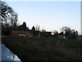
Bowling Green Farm.
Bowling Green Farm and outbuildings.
Image: © Paul Beaman
Taken: 10 Dec 2007
0.04 miles
2
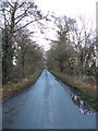
Along The Avenue
A view along the avenue, from Bowling Green Farm.
Image: © Paul Beaman
Taken: 10 Dec 2007
0.22 miles
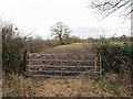
4

The Avenue near Peplow
A straight stretch of road lined with trees. Although I have not found any corroborative evidence, presumably its alignment with nearby Hodnet Hall means that it has some connection to the house.
See here for a winter view: Image]
Image: © Stephen Richards
Taken: Unknown
0.24 miles