IMAGES TAKEN NEAR TO
Ashwood Close, MARKET DRAYTON, TF9 3HF
Introduction
This page details the photographs taken nearby to Ashwood Close, TF9 3HF by members of the Geograph project.
The Geograph project started in 2005 with the aim of publishing, organising and preserving representative images for every square kilometre of Great Britain, Ireland and the Isle of Man.

There are currently over 7.5m images from over14,400 individuals and you can help contribute to the project by visiting https://www.geograph.org.uk
Image Map (Loading...)


Getting Data...Please wait
Leaflet Map data © OpenStreetMap
Images are licensed for reuse under creativecommons.org/licenses/by-sa/2.0
Notes
- Clicking on the map will re-center to the selected point.
- The higher the marker number, the further away the image location is from the centre of the postcode.
Image Listing (5 Images Found)
Images are licensed for reuse under creativecommons.org/licenses/by-sa/2.0
Image
Details
Distance
1
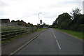
Longslow Road
Traffic calming measures in Longslow Road, Market Drayton.
Image: © Peter Fleming
Taken: 26 Aug 2007
0.13 miles
5
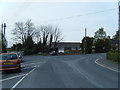
Old Toll House, Little Drayton
Toll House in the parish of Market Drayton on Shrewsbury Road.
To be surveyed
Milestone Society National ID: SA.MDR01
Image: © Milestone Society
Taken: Unknown
0.24 miles