IMAGES TAKEN NEAR TO
Maer Lane, MARKET DRAYTON, TF9 3AL
Introduction
This page details the photographs taken nearby to Maer Lane, TF9 3AL by members of the Geograph project.
The Geograph project started in 2005 with the aim of publishing, organising and preserving representative images for every square kilometre of Great Britain, Ireland and the Isle of Man.

There are currently over 7.5m images from over14,400 individuals and you can help contribute to the project by visiting https://www.geograph.org.uk
Image Map (Loading...)


Getting Data...Please wait
Leaflet Map data © OpenStreetMap
Images are licensed for reuse under creativecommons.org/licenses/by-sa/2.0
Notes
- Clicking on the map will re-center to the selected point.
- The higher the marker number, the further away the image location is from the centre of the postcode.
Image Listing (19 Images Found)
Images are licensed for reuse under creativecommons.org/licenses/by-sa/2.0
Image
Details
Distance
1

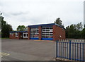
Market Drayton fire station
Market Drayton fire station, Maer Lane, Market Drayton, Shropshire.
Image: © Kevin Hale
Taken: 21 Oct 2006
0.05 miles
5
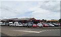
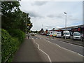
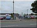
Car sales on Cheshire Street, Market Drayton
Image: © JThomas
Taken: 1 Jun 2019
0.10 miles
6
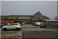
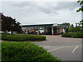
Morrison's supermarket, Cheshire Street, Market Drayton
Image: © Christopher Hilton
Taken: 1 Nov 2015
0.11 miles
8
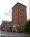
Former corn mill on Cheshire Street, Market Drayton
Now converted for mixed use.
Image: © JThomas
Taken: 1 Jun 2019
0.13 miles
9
Former corn mill, Cheshire Street, Market Drayton
Image: © Christopher Hilton
Taken: 1 Nov 2015
0.13 miles
10
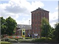
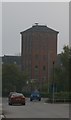
19th century industrial building, Market Drayton
On Cheshire Road.
Image: © Richard Webb
Taken: 25 Jul 2015
0.13 miles