IMAGES TAKEN NEAR TO
Chester Road, MARKET DRAYTON, TF9 2SY
Introduction
This page details the photographs taken nearby to Chester Road, TF9 2SY by members of the Geograph project.
The Geograph project started in 2005 with the aim of publishing, organising and preserving representative images for every square kilometre of Great Britain, Ireland and the Isle of Man.

There are currently over 7.5m images from over14,400 individuals and you can help contribute to the project by visiting https://www.geograph.org.uk
Image Map (Loading...)


Getting Data...Please wait
Leaflet Map data © OpenStreetMap
Images are licensed for reuse under creativecommons.org/licenses/by-sa/2.0
Notes
- Clicking on the map will re-center to the selected point.
- The higher the marker number, the further away the image location is from the centre of the postcode.
Image Listing (4 Images Found)
Images are licensed for reuse under creativecommons.org/licenses/by-sa/2.0
Image
Details
Distance
1
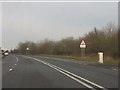
A41 - northern end of the Hinstock bypass
The original A41 route rejoins on the right.
Image: © Peter Whatley
Taken: 17 Jan 2012
0.07 miles

3

A41 Hinstock bypass
A welcome additional lane for traffic climbing the hill on what remains a busy route for commercial traffic.
Image: © Peter Whatley
Taken: 17 Jan 2012
0.21 miles
4

Hinstock Post Office and mini-roundabout
Image: © Colin Pyle
Taken: 24 Apr 2010
0.25 miles