IMAGES TAKEN NEAR TO
Pinfold Lane, MARKET DRAYTON, TF9 2QR
Introduction
This page details the photographs taken nearby to Pinfold Lane, TF9 2QR by members of the Geograph project.
The Geograph project started in 2005 with the aim of publishing, organising and preserving representative images for every square kilometre of Great Britain, Ireland and the Isle of Man.

There are currently over 7.5m images from over14,400 individuals and you can help contribute to the project by visiting https://www.geograph.org.uk
Image Map (Loading...)


Getting Data...Please wait
Leaflet Map data © OpenStreetMap
Images are licensed for reuse under creativecommons.org/licenses/by-sa/2.0
Notes
- Clicking on the map will re-center to the selected point.
- The higher the marker number, the further away the image location is from the centre of the postcode.
Image Listing (4 Images Found)
Images are licensed for reuse under creativecommons.org/licenses/by-sa/2.0
Image
Details
Distance
1
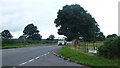
A53 at Sandy Lane crossroads
Looking west towards Market Drayton.
Image: © Jonathan Billinger
Taken: 6 Sep 2016
0.13 miles
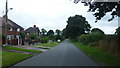
3

Crops and Lone Tree, Almington
The Newcastle way Through Almington Farm land
Image: © Brian Deegan
Taken: 12 Jun 2021
0.22 miles
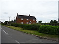
4
Houses on Sandy Lane
Looking south towards Almington.
Image: © Jonathan Billinger
Taken: 6 Sep 2016
0.22 miles