IMAGES TAKEN NEAR TO
Oakley Folly, MARKET DRAYTON, TF9 2QF
Introduction
This page details the photographs taken nearby to TF9 2QF by members of the Geograph project.
The Geograph project started in 2005 with the aim of publishing, organising and preserving representative images for every square kilometre of Great Britain, Ireland and the Isle of Man.

There are currently over 7.5m images from over14,400 individuals and you can help contribute to the project by visiting https://www.geograph.org.uk
Image Map (2 Images)


Getting Data...Please wait
Leaflet Map data © OpenStreetMap
Images are licensed for reuse under creativecommons.org/licenses/by-sa/2.0
Notes
- Clicking on the map will re-center to the selected point.
- The higher the marker number, the further away the image location is from the centre of the postcode.
Image Listing (2 Images Found)
Images are licensed for reuse under creativecommons.org/licenses/by-sa/2.0
Image
Details
Distance
1
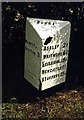
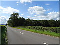
Old Milepost by the A53, The Folly, Loggerheads Parish
Cast iron post by the A53, in parish of LOGGERHEADS (NEWCASTLE UNDER LYME District), The Folly, East of Audley's Cross Farm, on grass verge in front of hedge, on South side of road. Lathe iron casting, erected by the County Council in the 19th/20th century.
Inscription reads:- : MARKET - / DRAYTON 3 : : BLORE : : ASHLEY 2½ / WHITMORE 6¾ / ECCLESHALL 8½ / NEWCASTLE 11 : : Chas. Lathe, Tipton. :
Grade II Listed. List Entry Number: 1029857
Milestone Society National ID: ST_MDNC03.
Image: © J Higgins
Taken: 1 Jan 2000
0.04 miles