IMAGES TAKEN NEAR TO
Hales, MARKET DRAYTON, TF9 2PP
Introduction
This page details the photographs taken nearby to TF9 2PP by members of the Geograph project.
The Geograph project started in 2005 with the aim of publishing, organising and preserving representative images for every square kilometre of Great Britain, Ireland and the Isle of Man.

There are currently over 7.5m images from over14,400 individuals and you can help contribute to the project by visiting https://www.geograph.org.uk
Image Map (16 Images)


Getting Data...Please wait
Leaflet Map data © OpenStreetMap
Images are licensed for reuse under creativecommons.org/licenses/by-sa/2.0
Notes
- Clicking on the map will re-center to the selected point.
- The higher the marker number, the further away the image location is from the centre of the postcode.
Image Listing (16 Images Found)
Images are licensed for reuse under creativecommons.org/licenses/by-sa/2.0
Image
Details
Distance
5
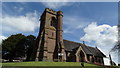
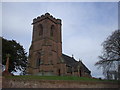
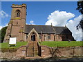
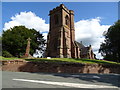
Hales near Market Drayton - St Mary's Church
Image: © Colin Park
Taken: 18 Apr 2017
0.11 miles
6
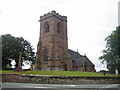
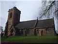
Hales: St Mary's Church
The church was founded in the mid-19th century by the Reverend Alexander Buchanan, 'squarson' of neighbouring Hales Hall. It was built to the designs of George Gilbert Scott and completed in 1856. The church is constructed of pink sandstone ashlar. The tower, with its prominent stepped angle buttresses, has a hexagonal stair turret attached to its south-east corner, on the right in the photograph. It is a Grade II Listed Building.
Image: © Nigel Cox
Taken: 15 Jun 2007
0.11 miles
7
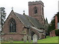
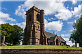
The Church of St Mary at Hales
Viewed from the east.
Image: © Peter Wood
Taken: 3 Dec 2016
0.11 miles
9
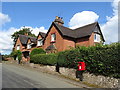
Houses in Hales
Showing position of Postbox No. TF9 2.
See Image] for postbox.
Image: © JThomas
Taken: 7 Sep 2019
0.15 miles
10
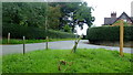
New Road grass triangle
Junction with the Almington road at Hales.
Tyrley Loop is a local footpath; see http://www.loggerheadsparishcouncil.co.uk/Pages/45/Walks+in+Loggerheads+Parish
Image: © Jonathan Billinger
Taken: 6 Sep 2016
0.15 miles