IMAGES TAKEN NEAR TO
Crofters Meadow, MARKET DRAYTON, TF9 2NU
Introduction
This page details the photographs taken nearby to Crofters Meadow, TF9 2NU by members of the Geograph project.
The Geograph project started in 2005 with the aim of publishing, organising and preserving representative images for every square kilometre of Great Britain, Ireland and the Isle of Man.

There are currently over 7.5m images from over14,400 individuals and you can help contribute to the project by visiting https://www.geograph.org.uk
Image Map (Loading...)


Getting Data...Please wait
Leaflet Map data © OpenStreetMap
Images are licensed for reuse under creativecommons.org/licenses/by-sa/2.0
Notes
- Clicking on the map will re-center to the selected point.
- The higher the marker number, the further away the image location is from the centre of the postcode.
Image Listing (24 Images Found)
Images are licensed for reuse under creativecommons.org/licenses/by-sa/2.0
Image
Details
Distance
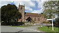
1

The Old School & School House, Cheswardine
Image: © Geoff Pick
Taken: 7 Dec 2007
0.02 miles
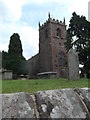
3
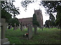
The Church of St Swithun at Cheswardine
Viewed from the north.
Image: © Peter Wood
Taken: 3 Dec 2016
0.06 miles
4
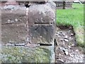
Ordnance Survey Cut Mark
This mark can be found on the wall of St Swithun's Church in Cheswardine.
For more detail see : http://www.bench-marks.org.uk/bm79834
Image: © Peter Wood
Taken: 3 Dec 2016
0.06 miles
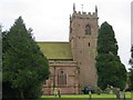
6
St Swithun's Church, Cheswardine
The church and churchyard from the North.
Image: © Eirian Evans
Taken: 6 Jul 2017
0.07 miles
7
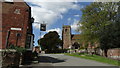
View of the tower of Cheswardine Church
This view is from Haywood Lane looking towards the church tower.
Image: © Michael Hendry
Taken: 17 Feb 2006
0.07 miles
8
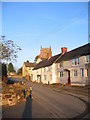
Cheswardine - Fox & Hounds PH & St Swithun's Church
Image: © Colin Park
Taken: 18 Apr 2017
0.07 miles
9

Old Direction Sign - Signpost by High Street, Cheswardine
Annulus finial - 3 Worboys arms; Shropshire CC halo by the UC road, in parish of Cheswardine (North Shropshire District), High Street junction with Church Lane, Cheswardine.
Surveyed
Milestone Society National ID: SA_SJ7129
Image: © Milestone Society
Taken: Unknown
0.08 miles
10
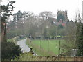
Cheswardine Church from the east
Taken on a grey morning this shows the road leading from the entrance to Cheswardine Hall and the church of St Swithun
Image: © Alan Wright
Taken: 19 Apr 2008
0.08 miles