IMAGES TAKEN NEAR TO
Goldstone, MARKET DRAYTON, TF9 2NA
Introduction
This page details the photographs taken nearby to TF9 2NA by members of the Geograph project.
The Geograph project started in 2005 with the aim of publishing, organising and preserving representative images for every square kilometre of Great Britain, Ireland and the Isle of Man.

There are currently over 7.5m images from over14,400 individuals and you can help contribute to the project by visiting https://www.geograph.org.uk
Image Map
Images are licensed for reuse under creativecommons.org/licenses/by-sa/2.0
Notes
- Clicking on the map will re-center to the selected point.
- The higher the marker number, the further away the image location is from the centre of the postcode.
Image Listing (8 Images Found)
Images are licensed for reuse under creativecommons.org/licenses/by-sa/2.0
Image
Details
Distance
2
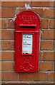
Edward VII postbox, Goldstone
Postbox No. TF9 444.
See Image] for context.
Image: © JThomas
Taken: 14 Mar 2020
0.05 miles
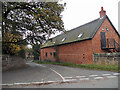
3
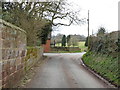
Barn conversion, Goldstone
Showing position of Postbox No. TF9 444.
See Image] for postbox.
Image: © JThomas
Taken: 14 Mar 2020
0.05 miles
5
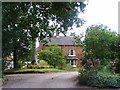
Goldstone Hall
The hamlet of Goldstone is in the parish of Cheswardine, just south of Market Drayton.
Image: © A Holmes
Taken: 24 Aug 2007
0.06 miles
6
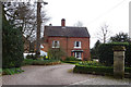
Goldstone Hall Country House Hotel
This was the former home of the Vardon family.
Image: © JThomas
Taken: 14 Mar 2020
0.07 miles