IMAGES TAKEN NEAR TO
Rosehill Road, MARKET DRAYTON, TF9 2LF
Introduction
This page details the photographs taken nearby to Rosehill Road, TF9 2LF by members of the Geograph project.
The Geograph project started in 2005 with the aim of publishing, organising and preserving representative images for every square kilometre of Great Britain, Ireland and the Isle of Man.

There are currently over 7.5m images from over14,400 individuals and you can help contribute to the project by visiting https://www.geograph.org.uk
Image Map
Images are licensed for reuse under creativecommons.org/licenses/by-sa/2.0
Notes
- Clicking on the map will re-center to the selected point.
- The higher the marker number, the further away the image location is from the centre of the postcode.
Image Listing (3 Images Found)
Images are licensed for reuse under creativecommons.org/licenses/by-sa/2.0
Image
Details
Distance
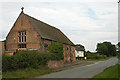
1
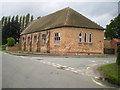
Stoke on Tern - Primary School
This shares a site with the local children's nursery.
Image: © Richard Law
Taken: 31 Aug 2009
0.13 miles
3
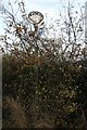
Direction Sign ? Signpost on the crossroads at Heathcote
Located on the southeast side of the crossroads of Rose Hill Road and Ollerton Lane at Heathcote in Stoke upon Tern parish. 3 arms and half-moon finial.
Milestone Society National ID: SA_SJ6528
Image: © J Haynes
Taken: Unknown
0.15 miles