IMAGES TAKEN NEAR TO
Ottley Way, MARKET DRAYTON, TF9 2ES
Introduction
This page details the photographs taken nearby to Ottley Way, TF9 2ES by members of the Geograph project.
The Geograph project started in 2005 with the aim of publishing, organising and preserving representative images for every square kilometre of Great Britain, Ireland and the Isle of Man.

There are currently over 7.5m images from over14,400 individuals and you can help contribute to the project by visiting https://www.geograph.org.uk
Image Map
Images are licensed for reuse under creativecommons.org/licenses/by-sa/2.0
Notes
- Clicking on the map will re-center to the selected point.
- The higher the marker number, the further away the image location is from the centre of the postcode.
Image Listing (4 Images Found)
Images are licensed for reuse under creativecommons.org/licenses/by-sa/2.0
Image
Details
Distance
2
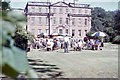
Buntingsdale Hall gathering - Market Drayton, Shropshire
This is Buntingsdale Hall, just to the south-west of Market Drayton. It once served as 22 Group HQ (Headquarters) of the RAF (Royal Air Force) and was parented for administration by the nearby RAF station at Tern Hill. Thanks to SJR for identifying this one. Time taken not available. Image
Image: © Mr Martin J Phelan
Taken: Unknown
0.19 miles
3
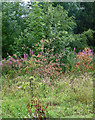
Vegetation near Market Drayton
Just struck by a pleasing variety of contrasting colours. Pink fireweed, reddish-brown dead leaves, and a variety of shades of green.
Image: © Stephen Richards
Taken: Unknown
0.19 miles
4
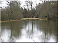
The Lake
On part of the Buntingsdale estate.
Image: © Paul Beaman
Taken: 14 Jan 2008
0.22 miles