IMAGES TAKEN NEAR TO
Mortimer Crescent, MARKET DRAYTON, TF9 2ER
Introduction
This page details the photographs taken nearby to Mortimer Crescent, TF9 2ER by members of the Geograph project.
The Geograph project started in 2005 with the aim of publishing, organising and preserving representative images for every square kilometre of Great Britain, Ireland and the Isle of Man.

There are currently over 7.5m images from over14,400 individuals and you can help contribute to the project by visiting https://www.geograph.org.uk
Image Map
Images are licensed for reuse under creativecommons.org/licenses/by-sa/2.0
Notes
- Clicking on the map will re-center to the selected point.
- The higher the marker number, the further away the image location is from the centre of the postcode.
Image Listing (5 Images Found)
Images are licensed for reuse under creativecommons.org/licenses/by-sa/2.0
Image
Details
Distance
2
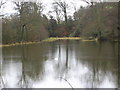
The Lake
On part of the Buntingsdale estate.
Image: © Paul Beaman
Taken: 14 Jan 2008
0.11 miles
3
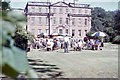
Buntingsdale Hall gathering - Market Drayton, Shropshire
This is Buntingsdale Hall, just to the south-west of Market Drayton. It once served as 22 Group HQ (Headquarters) of the RAF (Royal Air Force) and was parented for administration by the nearby RAF station at Tern Hill. Thanks to SJR for identifying this one. Time taken not available. Image
Image: © Mr Martin J Phelan
Taken: Unknown
0.13 miles
4
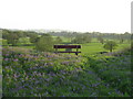
Fordhall earthwork
A picture taken from the Norman earthwork (a scheduled ancient monument) on Fordhall Farm.
Image: © Charlotte Hollins
Taken: 12 May 2008
0.20 miles
5
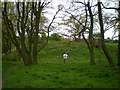
Castle Hill earthwork, Fordhall Farm
The hill behind the sign is the visible remains of the Ringwork and Bailey construction on Castle Hill, an English Heritage site, which preserves the remains of the castle built around 1100AD. Some earthworks are also evident on the south side, overlooking the Tern Valley. The original cobblestone floor lies a couple of feet down, and was discovered in the mid 1970s when trees were cleared on the site.
Image: © Richard Law
Taken: 26 Apr 2009
0.20 miles