IMAGES TAKEN NEAR TO
Wistanswick, MARKET DRAYTON, TF9 2EL
Introduction
This page details the photographs taken nearby to TF9 2EL by members of the Geograph project.
The Geograph project started in 2005 with the aim of publishing, organising and preserving representative images for every square kilometre of Great Britain, Ireland and the Isle of Man.

There are currently over 7.5m images from over14,400 individuals and you can help contribute to the project by visiting https://www.geograph.org.uk
Image Map (Loading...)


Getting Data...Please wait
Leaflet Map data © OpenStreetMap
Images are licensed for reuse under creativecommons.org/licenses/by-sa/2.0
Notes
- Clicking on the map will re-center to the selected point.
- The higher the marker number, the further away the image location is from the centre of the postcode.
Image Listing (7 Images Found)
Images are licensed for reuse under creativecommons.org/licenses/by-sa/2.0
Image
Details
Distance


4
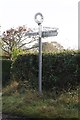
Old Direction Sign - Signpost in Wistanswick, Hodnet parish
Annulus finial - 3 arms; Shropshire CC modern halo by the UC road, in parish of Hodnet (North Shropshire District), Wistanswick.
Shropshire HER.
HER Number (PRN): 31205 https://www.heritagegateway.org.uk/Gateway/Results_Single.aspx?uid=MSA34049&resourceID=1015
Surveyed
Milestone Society National ID: SA_SJ6628B
Image: © Milestone Society
Taken: Unknown
0.17 miles