IMAGES TAKEN NEAR TO
Ollerton Lane, MARKET DRAYTON, TF9 2BS
Introduction
This page details the photographs taken nearby to Ollerton Lane, TF9 2BS by members of the Geograph project.
The Geograph project started in 2005 with the aim of publishing, organising and preserving representative images for every square kilometre of Great Britain, Ireland and the Isle of Man.

There are currently over 7.5m images from over14,400 individuals and you can help contribute to the project by visiting https://www.geograph.org.uk
Image Map (Loading...)


Getting Data...Please wait
Leaflet Map data © OpenStreetMap
Images are licensed for reuse under creativecommons.org/licenses/by-sa/2.0
Notes
- Clicking on the map will re-center to the selected point.
- The higher the marker number, the further away the image location is from the centre of the postcode.
Image Listing (11 Images Found)
Images are licensed for reuse under creativecommons.org/licenses/by-sa/2.0
Image
Details
Distance
1

WWII Shropshire: RAF/RNAS Hinstock/HMS Godwit - Control Tower (5)
Standard naval four-storey control tower, restored as a home in recent times named 'HMS Godwit'.
Image
Image: © Mike Searle
Taken: 12 Sep 2020
0.08 miles
2

WWII Shropshire: RAF/RNAS Hinstock/HMS Godwit - Building (6)
An unidentified building.
Image
Image: © Mike Searle
Taken: 12 Sep 2020
0.10 miles
3

WWII Shropshire: RAF/RNAS Hinstock/HMS Godwit - Building (7)
Interior of unidentified building with original light fitting.
Image
Image: © Mike Searle
Taken: 12 Sep 2020
0.10 miles
4

WWII Shropshire: RAF/RNAS Hinstock/HMS Godwit - The Firs Farm (8)
Aircraft 'tie-down' outside The Firs Farm. These cylindical concrete tie-down blocks are relics of the aviators' presence here. They can be seen at various locations in the area being reused as here at the entrance to The Firs Farm. Used to secure aircraft parked at dispersals during high winds etc.
Image
Image: © Mike Searle
Taken: 12 Sep 2020
0.10 miles
6

WWII Shropshire: RAF/RNAS Hinstock/HMS Godwit - Domestic Site (3)
Latrines.
Image
Image: © Mike Searle
Taken: 12 Sep 2020
0.16 miles
7

WWII Shropshire: RAF/RNAS Hinstock/HMS Godwit - Domestic Site (4)
Latrine.
Image
Image: © Mike Searle
Taken: 12 Sep 2020
0.16 miles
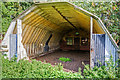
8

WWII Shropshire: RAF/RNAS Hinstock/HMS Godwit - Domestic Site (1)
A mixture of Nissen and Handcraft hutting barrack accommodation.
History:
Opened initially as a grass airfield in 1941 as RAF Ollerton, it was operated as an RAF Maintenance Unit, and also as a satellite landing ground (SLG) for RAF stations Burtonwood and Shawbury. In July 1943 it was rebuilt using heavy steel track for the runways and transferred to the Royal Navy who renamed it RNAS Hinstock, aka HMS Godwit. The standard four-storey control tower was probably added at this time https://www.geograph.org.uk/photo/6616143. The Navy's Fleet Air Arm at Hinstock specialised in instrument and blind approach flying training, operating a variety of aircraft that included Anson, Oxford, Swordfish, Harvard, Barracuda, Firefly and Whitley. It was Shropshire's only naval air base. The airfield was closed on 28 February 1947.
Image
Image: © Mike Searle
Taken: 12 Sep 2020
0.19 miles
9
WWII Shropshire: RAF/RNAS Hinstock/HMS Godwit - Domestic Site (2)
Seven-sided Handcraft hut.
Image
Image: © Mike Searle
Taken: 12 Sep 2020
0.19 miles