IMAGES TAKEN NEAR TO
Drummond Close, TELFORD, TF7 5UH
Introduction
This page details the photographs taken nearby to Drummond Close, TF7 5UH by members of the Geograph project.
The Geograph project started in 2005 with the aim of publishing, organising and preserving representative images for every square kilometre of Great Britain, Ireland and the Isle of Man.

There are currently over 7.5m images from over14,400 individuals and you can help contribute to the project by visiting https://www.geograph.org.uk
Image Map
Images are licensed for reuse under creativecommons.org/licenses/by-sa/2.0
Notes
- Clicking on the map will re-center to the selected point.
- The higher the marker number, the further away the image location is from the centre of the postcode.
Image Listing (13 Images Found)
Images are licensed for reuse under creativecommons.org/licenses/by-sa/2.0
Image
Details
Distance
3

Path to Newcomen Way at Woodside, Telford
Image: © Mat Fascione
Taken: 1 Sep 2023
0.12 miles
4

Path at Rough Park, Coalbrookdale
Rough Park was formerly an open cast mining site, it covers 42.3 hectares of horse grazed paddocks, woodland plantations and grassland. It was declared as a Local Nature Reserve in 2023.
Image: © Mat Fascione
Taken: 1 Sep 2023
0.15 miles
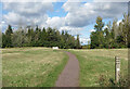
5

Rough Park at Coalbrookdale
Rough Park was formerly an open cast mining site, it covers 42.3 hectares of horse grazed paddocks, woodland plantations and grassland. It was declared as a Local Nature Reserve in 2023.
Image: © Mat Fascione
Taken: 1 Sep 2023
0.15 miles
6

Rough Park at Coalbrookdale
Rough Park was formerly an open cast mining site, it covers 42.3 hectares of horse grazed paddocks, woodland plantations and grassland. It was declared as a Local Nature Reserve in 2023.
Image: © Mat Fascione
Taken: 1 Sep 2023
0.17 miles
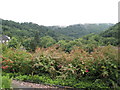
7
Rough Park, Coalbrookdale
An area of grass meadow and woodland above the Coalbrookdale valley.
A lot of public footpaths are shown nearby. In Victorian times the Coalbrookdale ironworks proprietors laid out a series of "Sunday Walks" up here for people to get some fresh air away from the industrial valleys.
Image: © Des Blenkinsopp
Taken: 28 Sep 2022
0.18 miles
8

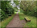
Path and seat at Rough Park
Rough Park was formerly an open cast mining site, it covers 42.3 hectares of horse grazed paddocks, woodland plantations and grassland. It was declared as a Local Nature Reserve in 2023.
Image: © Mat Fascione
Taken: 1 Sep 2023
0.18 miles
9
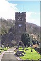
View from the churchyard at Holy Trinity, Coalbrookdale
Image: © Basher Eyre
Taken: 12 Aug 2009
0.20 miles
10

Steps in Oilhouse Coppice at Rough Park
Image: © Mat Fascione
Taken: 1 Sep 2023
0.20 miles