IMAGES TAKEN NEAR TO
Westbourne, TELFORD, TF7 5QP
Introduction
This page details the photographs taken nearby to Westbourne, TF7 5QP by members of the Geograph project.
The Geograph project started in 2005 with the aim of publishing, organising and preserving representative images for every square kilometre of Great Britain, Ireland and the Isle of Man.

There are currently over 7.5m images from over14,400 individuals and you can help contribute to the project by visiting https://www.geograph.org.uk
Image Map
Images are licensed for reuse under creativecommons.org/licenses/by-sa/2.0
Notes
- Clicking on the map will re-center to the selected point.
- The higher the marker number, the further away the image location is from the centre of the postcode.
Image Listing (4 Images Found)
Images are licensed for reuse under creativecommons.org/licenses/by-sa/2.0
Image
Details
Distance
1
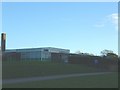
Woodlands Primary School
...in Woodside, for 5-11 year olds. Situated just across the car park from the Community Centre.
Image: © Steve McShane
Taken: 12 Nov 2005
0.09 miles
3
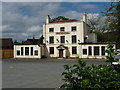
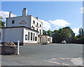
The Beacon pub, Madeley Wood
A landmark pub at the top of Madeley Hill, and a Grade II listed building https://www.britishlistedbuildings.co.uk/101207739-the-beacon-public-house-madeley#.WWPq5NQrLGg granted in 1983. It's no longer trading; the site is surrounded by hoardings and fencework, and it looks like conversion to flats or similar may well be the next phase of this place's life.
Image: © Richard Law
Taken: 24 Jun 2017
0.19 miles
4
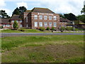
The 'Ab-Dab' school, Madeley
Named after one of the area's most famous residents, an ironmaster of some repute in his day, the Abraham Darby school sits at the top of the Ironbridge Road in Madeley www.abrahamdarbyacademy.org.uk
Image: © Richard Law
Taken: 15 May 2010
0.22 miles