IMAGES TAKEN NEAR TO
Warrensway, TELFORD, TF7 5QD
Introduction
This page details the photographs taken nearby to Warrensway, TF7 5QD by members of the Geograph project.
The Geograph project started in 2005 with the aim of publishing, organising and preserving representative images for every square kilometre of Great Britain, Ireland and the Isle of Man.

There are currently over 7.5m images from over14,400 individuals and you can help contribute to the project by visiting https://www.geograph.org.uk
Image Map
Images are licensed for reuse under creativecommons.org/licenses/by-sa/2.0
Notes
- Clicking on the map will re-center to the selected point.
- The higher the marker number, the further away the image location is from the centre of the postcode.
Image Listing (4 Images Found)
Images are licensed for reuse under creativecommons.org/licenses/by-sa/2.0
Image
Details
Distance
2
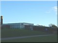
Woodlands Primary School
...in Woodside, for 5-11 year olds. Situated just across the car park from the Community Centre.
Image: © Steve McShane
Taken: 12 Nov 2005
0.19 miles
3
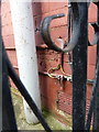
OS benchmark - Ironbridge, 49 Beech Road
A rather inaccessible benchmark on the gable wall of the house; originally levelled at 131.549m above Ordnance Datum Newlyn.
Image: © Richard Law
Taken: 27 Mar 2016
0.22 miles