IMAGES TAKEN NEAR TO
Sampson Park, TELFORD, TF7 5FD
Introduction
This page details the photographs taken nearby to Sampson Park, TF7 5FD by members of the Geograph project.
The Geograph project started in 2005 with the aim of publishing, organising and preserving representative images for every square kilometre of Great Britain, Ireland and the Isle of Man.

There are currently over 7.5m images from over14,400 individuals and you can help contribute to the project by visiting https://www.geograph.org.uk
Image Map
Images are licensed for reuse under creativecommons.org/licenses/by-sa/2.0
Notes
- Clicking on the map will re-center to the selected point.
- The higher the marker number, the further away the image location is from the centre of the postcode.
Image Listing (32 Images Found)
Images are licensed for reuse under creativecommons.org/licenses/by-sa/2.0
Image
Details
Distance
1
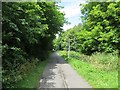
Coalport Branch
Now a paved path and part of the National Cycle Network.
Image: © Richard Webb
Taken: 30 Jun 2014
0.06 miles
2
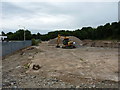
Site clearance work on Tweedale Industrial Estate
A large pile of concrete & brickwork for reclamation at the back of the Industrial Estate, much of it presumably the work of the JCB excavator.
Image: © Richard Law
Taken: 4 Jun 2020
0.07 miles
3
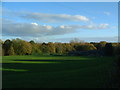
School Fields?
The fields that were formerly part of the school. I guess they still could be, but there are now railings that separate them.
Image: © Steve McShane
Taken: 12 Nov 2005
0.09 miles
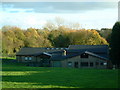
4
St Mary's 2
Closer shot of the school, where the entrances are.
Image: © Steve McShane
Taken: 12 Nov 2005
0.14 miles
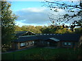
5
St Mary's RC School, Madeley
Madeley's Catholic Primary school for 5-11 year olds. This view was taken from what used to be the school's playing fields and football pitches. I'm not sure now though who owns the land.
Image: © Steve McShane
Taken: 12 Nov 2005
0.14 miles
6
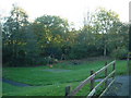
A place to play...
...for the local children of Coronation Crescent.
Image: © Steve McShane
Taken: 12 Nov 2005
0.14 miles
7
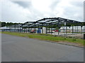
Tweedale Industrial Estate
A new unit in the course of construction amongst the other light industrial buildings on Tweedale Estate. It's not yet clear from signage what this one might end up being.
Image: © Richard Law
Taken: 4 Jun 2020
0.15 miles
8
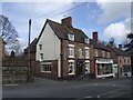
Royal Oak, Madeley
King Charles II hid in the 'Royal Barn' in Madeley on his flight from the Battle of Worcester in 1651.
Image: © John M
Taken: 9 Mar 2008
0.20 miles
9
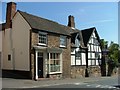
Madeley - Timber Framed House
One of the oldest buildings on the High Street Madeley
Image: © Ian Slater
Taken: Unknown
0.20 miles
10
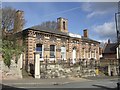
Lumley Hall
The home of Telford Amateur Boxing Club opened as the County Court House in 1858.
Image: © John M
Taken: 9 Mar 2008
0.20 miles