IMAGES TAKEN NEAR TO
Mill Lane, TELFORD, TF7 5DY
Introduction
This page details the photographs taken nearby to Mill Lane, TF7 5DY by members of the Geograph project.
The Geograph project started in 2005 with the aim of publishing, organising and preserving representative images for every square kilometre of Great Britain, Ireland and the Isle of Man.

There are currently over 7.5m images from over14,400 individuals and you can help contribute to the project by visiting https://www.geograph.org.uk
Image Map
Images are licensed for reuse under creativecommons.org/licenses/by-sa/2.0
Notes
- Clicking on the map will re-center to the selected point.
- The higher the marker number, the further away the image location is from the centre of the postcode.
Image Listing (97 Images Found)
Images are licensed for reuse under creativecommons.org/licenses/by-sa/2.0
Image
Details
Distance
1
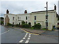
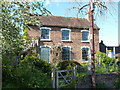
13 & 14 Station Road, Madeley
Partially 17th century, partially 18th century, and stuccoed in the 19th, this pair of houses was Grade II listed https://britishlistedbuildings.co.uk/101352030-13-and-14-station-road-madeley#.W8WF7WhKhPY in 1983. The listing includes the cast-iron railings at the front, which were likely to have been made in Coalbrookdale.
Image: © Richard Law
Taken: 8 Sep 2018
0.03 miles
2
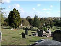
St Michaels Churchyard, Madeley
Looking East across the churchyard towards the Sutton Hill area of Telford.
Image: © Gordon Cragg
Taken: 23 Oct 2003
0.03 miles
3
Nos 2 - 5 Station Road, Madeley
A terrace of late 18th or early 19th century stuccoed houses, which were Grade II listed https://www.britishlistedbuildings.co.uk/101033290-2-5-station-road-madeley#.WuMcXtQrLGg in 1983.
Image: © Richard Law
Taken: 7 Apr 2018
0.06 miles
4
8 Station Road, Madeley
A private house operating a B&B business, no 8 Station Road was built in the mid 19th century, and was Grade II listed https://britishlistedbuildings.co.uk/101208870-no-8-station-road-madeley#.XOq4U4hKjcs & https://historicengland.org.uk/listing/the-list/list-entry/1208870 in 1983.
Image: © Richard Law
Taken: 11 May 2019
0.06 miles
5
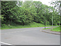
Legges Way at Junction with Blsts Hill entry road
Image: © John Firth
Taken: 15 Jun 2010
0.06 miles
6
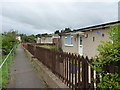
Prefabs on Station Road
A long row of prefab bungalows, probably built in the 1960s under the auspices of the Telford Development Corporation, on Station Road in Madeley. If the date of erection is correct, they are probably the 'Mowlem' model, built of cast in-situ concrete and a tiled roof.
Image: © Richard Law
Taken: 8 Sep 2018
0.07 miles
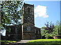
7
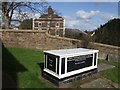
Cast iron tomb
Unusual cast iron tomb dating from 1810 to the Swiss born pastor John de la Flechere. John was one of the principal theologians of the Evangelical Revival and a friend of John Wesley.
He was vicar here at St Michaels for 25 years.
Image: © John M
Taken: 9 Mar 2008
0.08 miles
8
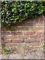
OS benchmark - Madeley, wall on Station Road
An OS cutmark on the boundary wall of No 3, Station Road; originally levelled at 104.732m above Ordnance Datum Newlyn.
Image: © Richard Law
Taken: 19 Sep 2015
0.09 miles
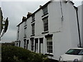
9
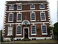
The Old Vicarage, Madeley
The vicarage was built around 1700, which suggests it originally served an earlier church than the one which stands just to its west now Image; it was Grade II* listed https://www.britishlistedbuildings.co.uk/101352023-the-old-vicarage-madeley#.WuF5N_nwaM8 in 1983, and is notable for a number of interior timber-framed walls, and for being the home of the Revd John Fletcher http://madeleylocalhistory.org/people/fletcher.html a local Methodist preacher from 1760 to 1785.
Image: © Richard Law
Taken: 7 Apr 2018
0.09 miles