
IMAGES TAKEN NEAR TO
Upper Road, TELFORD, TF7 5DQ
Introduction
This page details the photographs taken nearby to Upper Road, TF7 5DQ by members of the Geograph project.
The Geograph project started in 2005 with the aim of publishing, organising and preserving representative images for every square kilometre of Great Britain, Ireland and the Isle of Man.

There are currently over 7.5m images from over14,400 individuals and you can help contribute to the project by visiting https://www.geograph.org.uk
Image Map
Images are licensed for reuse under creativecommons.org/licenses/by-sa/2.0
Notes
- Clicking on the map will re-center to the selected point.
- The higher the marker number, the further away the image location is from the centre of the postcode.
Image Listing (56 Images Found)
Images are licensed for reuse under creativecommons.org/licenses/by-sa/2.0
Image
Details
Distance
1
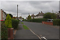
South Drive, Madeley
Local authority built housing to the south west of Madeley town centre.
Image: © Stephen McKay
Taken: 10 Oct 2015
0.05 miles
2
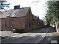
The 'Royal Barn'
King Charles II and Richard Penderell hid from Parliamentary troops in this barn during the day of 6th September 1651 following the Battle of Worcester. Later that evening they left to return to Boscobel.
The barn has been converted to residential use.
Image: © John M
Taken: 9 Mar 2008
0.12 miles
3

Coach House and Barn to the NW of Upper Hall
Grade II listed https://www.britishlistedbuildings.co.uk/101033273-coach-house-and-barn-north-west-of-upper-house-madeley#.WuAiJfnwaM8 in 1968, the main barn is believed to be 17th century, whilst the coach house (brickwork glimpsed on the right here) is dated 1765. The barn served as a market hall for Madeley in the 18th century, and hid the fugitive King Charles II in the 1650s from Cromwell's army, apparently the day before his famous escapade in the Boscobel oak tree Image
Image: © Richard Law
Taken: 7 Apr 2018
0.12 miles
4

Garden boundary wall to The Old Hall
Grade II listed in itself https://www.britishlistedbuildings.co.uk/101208661-garden-boundary-wall-south-west-of-the-old-hall-madeley#.WuAf9_nwaM8 in 1983, this sandstone ashlar wall and coping surrounds the grounds of the II* listed Image
Image: © Richard Law
Taken: 7 Apr 2018
0.13 miles
5
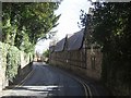
The 'Royal Barn'
King Charles II and Richard Penderell hid from Parliamentary troops in this barn during the day of 6th September 1651 following the Battle of Worcester. Later that evening they left to return to Boscobel.
The barn has been converted to residential use.
Image: © John M
Taken: 9 Mar 2008
0.13 miles
6

Garden gazebo by The Old Hall
Looking rather better than it did in 1968 at the time of its Grade II listing https://www.britishlistedbuildings.co.uk/101033271-gazebo-south-south-east-of-the-old-hall-madeley#.WuAdTfnwaM8 (the collapsed roof has been rebuilt in the meantime) this small square brick building dates to the 18th century.
Image: © Richard Law
Taken: 7 Apr 2018
0.14 miles
7
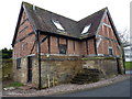
Stables & Mounting Block west of The Old Hall
A 17th century stables and stone mounting block, which were collectively Grade II listed https://www.britishlistedbuildings.co.uk/101033270-stables-and-mounting-block-immediately-west-of-the-old-hall-madeley#.WuAed_nwaM8 in 1983.
Image: © Richard Law
Taken: 7 Apr 2018
0.14 miles
8
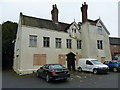
Upper House, Madeley
A building with something of a history. It has roughly three separately-identifiable periods to it; the first being an early 17th century, timber framed core (probably 1620s) on the west side, which was built by the Royalist sympathiser Francis Wolfe, a local mining and ironworks industrialist. In the 18th, this 2.5 storey wing was added, and then later in the same century a couple of extensions to the back. The whole place was Grade II listed https://www.britishlistedbuildings.co.uk/101208668 & https://historicengland.org.uk/listing/the-list/list-entry/1208668 in 1983, but is currently awaiting the next phase of its life, after most recent use as local court. It is looking somewhat forlorn in early 2018.
Update August 2020. Planning permission has been granted for 'sensitive conversion' of the property into eight flats. This should save the place from further deterioration as a result of neglect, vandalism and inappropriate alteration.
Image: © Richard Law
Taken: 7 Apr 2018
0.14 miles
9
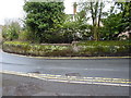
Garden boundary wall arouind Upper House
A sandstone and ashlar wall around the grounds of Image, which dates from the 18th century, and was Grade II listed https://www.britishlistedbuildings.co.uk/101033272-garden-boundary-wall-immediately-north-east-of-upper-house-madeley#.WuFxZ_nwaM8 in 1983.
Image: © Richard Law
Taken: 7 Apr 2018
0.14 miles
10
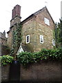
No 7 Church Street, Madeley
A late 17th or early 18th century cottage, Grade II listed https://www.britishlistedbuildings.co.uk/101208689-7-church-street-madeley#.WuFyFvnwaM8 in 1983. It was extended (upwards, by the addition of the brick attic and a new roof, and probably also the chimney stacks) in the 19th century.
Image: © Richard Law
Taken: 7 Apr 2018
0.14 miles