IMAGES TAKEN NEAR TO
High Street, TELFORD, TF7 5AS
Introduction
This page details the photographs taken nearby to High Street, TF7 5AS by members of the Geograph project.
The Geograph project started in 2005 with the aim of publishing, organising and preserving representative images for every square kilometre of Great Britain, Ireland and the Isle of Man.

There are currently over 7.5m images from over14,400 individuals and you can help contribute to the project by visiting https://www.geograph.org.uk
Image Map
Images are licensed for reuse under creativecommons.org/licenses/by-sa/2.0
Notes
- Clicking on the map will re-center to the selected point.
- The higher the marker number, the further away the image location is from the centre of the postcode.
Image Listing (69 Images Found)
Images are licensed for reuse under creativecommons.org/licenses/by-sa/2.0
Image
Details
Distance
1
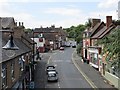
Madeley High Street
View from the bridge on the Silkin Way.
Image: © Richard Webb
Taken: 30 Jun 2014
0.01 miles
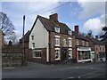
2
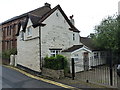
Cottage on Station Road, Madeley
Despite the datestone in the gable (1690) this late 17th century rubblestone cottage appears to have evaded being listed. The brick upper storey with its dormer windows is clearly a much later (probably 19th century) addition. Maybe the alterations are simply too substantial to leave much of the original fabric intact.
Image: © Richard Law
Taken: 8 Sep 2018
0.02 miles
3
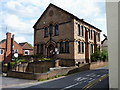
The former Mount Zion Primitive Methodist Chapel, Madeley
Now the home to a small printing business, the chapel was erected in 1865 and ceased to be a place of worship in 1977. It is currently known as The People's Centre in Madeley.
Image: © Richard Law
Taken: 15 May 2010
0.02 miles
4
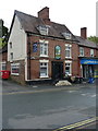
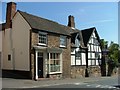
The (former) Royal Oak, Madeley
Until fairly recently still a pub, certainly it was such only 10 years ago anyway Image, this is now the Kashmir Cafe Restaurant and takeaway. The building itself dates from the 18th century, and was Grade II listed https://britishlistedbuildings.co.uk/101033278-the-royal-oak-madeley#.W88UvNQrLGg in 1983.
Image: © Richard Law
Taken: 8 Sep 2018
0.02 miles
5
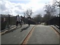
Runners on the Silkin Way
The Silkin Way, named after John Silkin, follow the line of the LNWR Coalport Branch. The runners in the Telford half marathon have climbed up from Blist's Hill Museum at some ten and a half miles and are looking the worse for wear.
Image: © John M
Taken: 9 Mar 2008
0.03 miles
6
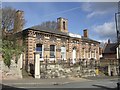
Lumley Hall
The home of Telford Amateur Boxing Club opened as the County Court House in 1858.
Image: © John M
Taken: 9 Mar 2008
0.03 miles
7
Madeley - Timber Framed House
One of the oldest buildings on the High Street Madeley
Image: © Ian Slater
Taken: Unknown
0.03 miles
8
Forester's Arms
A pub seen from the Silkin Way at the east end of Madeley High Street.
Image: © Richard Webb
Taken: 30 Jun 2014
0.03 miles
9
Royal Oak, Madeley
King Charles II hid in the 'Royal Barn' in Madeley on his flight from the Battle of Worcester in 1651.
Image: © John M
Taken: 9 Mar 2008
0.03 miles
10
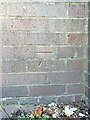
OS benchmark - Madeley, retaining wall at bottom of High St
An OS cutmark on a relatively modern piece of urban architecture - a retaining wall below the bridge which now carries the former railway line over the High St. It was cut and levelled in 1979, and marks a point 99.639m above Ordnance Datum Newlyn.
Image: © Richard Law
Taken: 26 Jul 2024
0.03 miles