IMAGES TAKEN NEAR TO
Bridgnorth Road, TELFORD, TF7 4JB
Introduction
This page details the photographs taken nearby to Bridgnorth Road, TF7 4JB by members of the Geograph project.
The Geograph project started in 2005 with the aim of publishing, organising and preserving representative images for every square kilometre of Great Britain, Ireland and the Isle of Man.

There are currently over 7.5m images from over14,400 individuals and you can help contribute to the project by visiting https://www.geograph.org.uk
Image Map
Images are licensed for reuse under creativecommons.org/licenses/by-sa/2.0
Notes
- Clicking on the map will re-center to the selected point.
- The higher the marker number, the further away the image location is from the centre of the postcode.
Image Listing (17 Images Found)
Images are licensed for reuse under creativecommons.org/licenses/by-sa/2.0
Image
Details
Distance
1
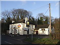
The Three Furnaces, Madeley Wood, Telford and Wrekin
Former Greenalls pub with an all to familiar sign outside.
Image: © al partington
Taken: 5 Dec 2007
0.08 miles
2
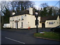
The Three Furnaces, Madeley Wood
In the two years since Image was taken, the pub's been taken over, and had some new signage, by the look of things.
Image: © Richard Law
Taken: 5 Dec 2009
0.08 miles
3
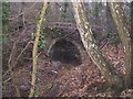
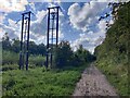
Tramway Tunnel
This is the remains of a tramway tunnel.
Image: © Roger Dean
Taken: 22 Dec 2005
0.10 miles
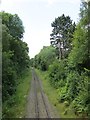
4
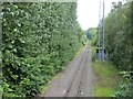
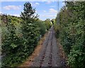
Buildwas power station railway
Railway supplying Buildwas with coal. The power station will soon close, and it will be interesting to see what happens to the railway.
Image: © Richard Webb
Taken: 30 Jun 2014
0.14 miles
5
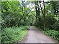
Coalport Branch
Former railway, now a paved path. Here it runs through woodland near Madeley Court.
Image: © Richard Webb
Taken: 30 Jun 2014
0.14 miles
6
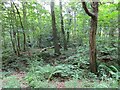
Woodland, Madeley
Wooded former industrial land.
Image: © Richard Webb
Taken: 30 Jun 2014
0.14 miles
9
Buildwas power station railway
A branch line supplies Buildwas power station with coal.
Image: © Richard Webb
Taken: 30 Jun 2014
0.17 miles
10
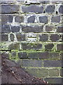
OS benchmark - Tweedale, bridge on Rough Park Way
An OS cutmark on the abutment of the long-disused railway bridge which now carries the Silkin Way over the Rough Park Way path. This one was originally levelled at 110.7m above Ordnance Datum Newlyn.
Image: © Richard Law
Taken: 15 Aug 2015
0.17 miles