IMAGES TAKEN NEAR TO
Princes End, TELFORD, TF4 2JR
Introduction
This page details the photographs taken nearby to Princes End, TF4 2JR by members of the Geograph project.
The Geograph project started in 2005 with the aim of publishing, organising and preserving representative images for every square kilometre of Great Britain, Ireland and the Isle of Man.

There are currently over 7.5m images from over14,400 individuals and you can help contribute to the project by visiting https://www.geograph.org.uk
Image Map
Images are licensed for reuse under creativecommons.org/licenses/by-sa/2.0
Notes
- Clicking on the map will re-center to the selected point.
- The higher the marker number, the further away the image location is from the centre of the postcode.
Image Listing (11 Images Found)
Images are licensed for reuse under creativecommons.org/licenses/by-sa/2.0
Image
Details
Distance
1
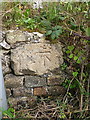
OS benchmark - Dawley Bank, Ladygrove
An OS cutmark on the wall on the east side of Ladygrove, a lane that leads south from Station Road. Originally levelled at 193.365m above Ordnance Datum Newlyn.
Image: © Richard Law
Taken: 14 Sep 2014
0.05 miles
2
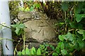
Ladygrove Benchmark
The OS cut benchmark on Ladygrove Lane - W3W: servants.roaring.exporters. It was last verified by the OS in 1961
Image: © Anthony Rowley
Taken: 23 Jul 2021
0.05 miles
3
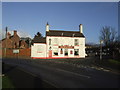
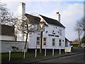
The Bulls Head, Dawley Bank, Telford and Wrekin
Much more of a 'traditional' boozer than the adjacent Wrekin View.
Image: © al partington
Taken: 5 Dec 2007
0.07 miles
5
The Wrekin View, Dawley Bank, Telford and Wrekin
1980's Banks's brewery addition to Dawley Bank with a self-explanatory view.
Image: © al partington
Taken: 5 Dec 2007
0.08 miles
7
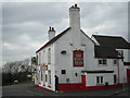
The Queen's Arms, Dawley Bank
A free house on Bank Road.
Image: © Richard Law
Taken: 24 Jan 2010
0.11 miles
8
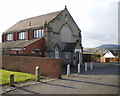
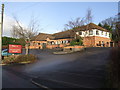
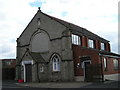
Beacon House, Dawley Bank
No longer the Wesleyan Sunday School that is marked on the plaque on the original remaining gable; this is now a private residence, and the gable is all that's left of the Methodist Chapel and Sunday School buildings.
Image: © Richard Law
Taken: 24 Jan 2010
0.15 miles
9
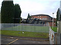
My gun's bigger than your gun!
This (Chieftain?) tank sits outside the Dawley Territorial Army centre, the local base of the Royal Mercian and Lancastrian Yeomanry. Don't mess with them.
Image: © Richard Law
Taken: 24 Jan 2010
0.19 miles
10
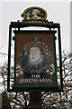
Queens Arms, Dawley Bank, pub sign
Poor Elizabeth's looking the worse for wear, but a nice sign, nevertheless. The other side's better, but there's a tree in the way. The pub: Image
Image: © Mike White
Taken: 27 Jan 2010
0.21 miles