IMAGES TAKEN NEAR TO
Brookes Avenue, TELFORD, TF3 5FE
Introduction
This page details the photographs taken nearby to Brookes Avenue, TF3 5FE by members of the Geograph project.
The Geograph project started in 2005 with the aim of publishing, organising and preserving representative images for every square kilometre of Great Britain, Ireland and the Isle of Man.

There are currently over 7.5m images from over14,400 individuals and you can help contribute to the project by visiting https://www.geograph.org.uk
Image Map
Images are licensed for reuse under creativecommons.org/licenses/by-sa/2.0
Notes
- Clicking on the map will re-center to the selected point.
- The higher the marker number, the further away the image location is from the centre of the postcode.
Image Listing (19 Images Found)
Images are licensed for reuse under creativecommons.org/licenses/by-sa/2.0
Image
Details
Distance
1
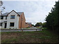
New houses on Baxter Drive
The extensive Lawley Furnaces estate continues to grow; these are among the more recently built houses in the area, but they're still putting 'em up nearby.
Image: © Richard Law
Taken: 20 Sep 2022
0.12 miles
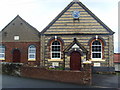
4

Chapel Clock
This attractive clock is on the outside wall of the Primitive Methodist's Chapel at The Rock.Image
Image: © Gordon Cragg
Taken: 5 May 2009
0.14 miles
5
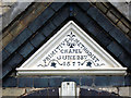
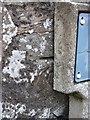
Chapel Wall Stone
This stone is situated above the lintel of the main entrance to the Primitive Methodist's Chapel at The Rock. Image
Image: © Gordon Cragg
Taken: 5 May 2009
0.15 miles
6
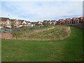
Attenuation pond just off Churchward Drive
Just like Image, this too is marked on the maps as a Balancing Pond, and its primary purpose is to catch excessive run-off of rainwater from surrounding roads in wet weather, store the water temporarily, and then release it into the drainage systems and eventually into the natural watercourse. Flood prevention, or at least flood reduction, is the main aim.
Image: © Richard Law
Taken: 20 Sep 2022
0.15 miles
7
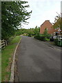
Gresham Drive, Lawley Furnaces estate
A cul-de-sac road in the extensive housing estate of Lawley Furnaces
Image: © Richard Law
Taken: 20 Sep 2022
0.16 miles
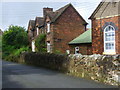
8
OS benchmark - The Rock chapel wall
An OS cutmark on the boundary wall right outside Image albeit just off shot to the right of that picture. It was originally levelled at 182.06m above Ordnance Datum Newlyn.
Image: © Richard Law
Taken: 14 Sep 2014
0.16 miles
10
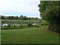
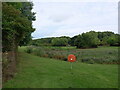
The northern end of Newdale Pond
Newdale pond is a landscaped pool in the middle of the extensive Lawley Furnaces housing estate.
Image: © Richard Law
Taken: 20 Sep 2022
0.17 miles