
IMAGES TAKEN NEAR TO
Cedar Close, TELFORD, TF3 5BW
Introduction
This page details the photographs taken nearby to Cedar Close, TF3 5BW by members of the Geograph project.
The Geograph project started in 2005 with the aim of publishing, organising and preserving representative images for every square kilometre of Great Britain, Ireland and the Isle of Man.

There are currently over 7.5m images from over14,400 individuals and you can help contribute to the project by visiting https://www.geograph.org.uk
Image Map
Images are licensed for reuse under creativecommons.org/licenses/by-sa/2.0
Notes
- Clicking on the map will re-center to the selected point.
- The higher the marker number, the further away the image location is from the centre of the postcode.
Image Listing (20 Images Found)
Images are licensed for reuse under creativecommons.org/licenses/by-sa/2.0
Image
Details
Distance
1

Shared-use path at The Rock
One section of a pathway that runs pretty much from Old Park to the east, almost into the woods at the foot of The Ercall hill.
Image: © Richard Law
Taken: 3 Apr 2025
0.04 miles
2

Rock Road near Newdale
The lights mark the position of a pedestrian crossing, where a shared-use (foot & cycle) path crosses Rock Road.
Image: © Richard Law
Taken: 3 Apr 2025
0.04 miles
3

Open land at The Rock
A patch of undeveloped land just north of the lane that runs through this area, seen here from the top of a steep bank - probably the edge of an old coal tip or waste pile.
Image: © Richard Law
Taken: 3 Apr 2025
0.09 miles
4

Horseshoe Cottage, The Rock
A former blacksmith's shop at The Rock, Telford. Now converted into an attractive cottage residence.
Image: © Gordon Cragg
Taken: Unknown
0.09 miles
6

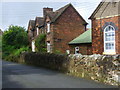
OS benchmark - The Rock, 27 Mannerley Lane
An OS cutmark on the east face of no 27; originally levelled in 1961 at 150.154m above Ordnance Datum Newlyn.
Image: © Richard Law
Taken: 14 Sep 2014
0.13 miles
7
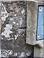
OS benchmark - The Rock chapel wall
An OS cutmark on the boundary wall right outside Image albeit just off shot to the right of that picture. It was originally levelled at 182.06m above Ordnance Datum Newlyn.
Image: © Richard Law
Taken: 14 Sep 2014
0.13 miles
8

Chapel Clock
This attractive clock is on the outside wall of the Primitive Methodist's Chapel at The Rock.Image
Image: © Gordon Cragg
Taken: 5 May 2009
0.13 miles
9
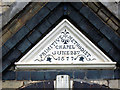
Chapel Wall Stone
This stone is situated above the lintel of the main entrance to the Primitive Methodist's Chapel at The Rock. Image
Image: © Gordon Cragg
Taken: 5 May 2009
0.13 miles
