IMAGES TAKEN NEAR TO
Hall Park Way, TELFORD, TF3 4LR
Introduction
This page details the photographs taken nearby to Hall Park Way, TF3 4LR by members of the Geograph project.
The Geograph project started in 2005 with the aim of publishing, organising and preserving representative images for every square kilometre of Great Britain, Ireland and the Isle of Man.

There are currently over 7.5m images from over14,400 individuals and you can help contribute to the project by visiting https://www.geograph.org.uk
Image Map
Images are licensed for reuse under creativecommons.org/licenses/by-sa/2.0
Notes
- Clicking on the map will re-center to the selected point.
- The higher the marker number, the further away the image location is from the centre of the postcode.
Image Listing (52 Images Found)
Images are licensed for reuse under creativecommons.org/licenses/by-sa/2.0
Image
Details
Distance
1
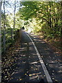
A shared use pathway near the Land Registry offices
This pathway runs between the offices of the Land Registry (on the left) and retail units over to the right.
Image: © Richard Law
Taken: 18 Oct 2022
0.06 miles
2
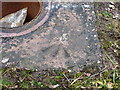
OS rivet at Malinslee
An OS cutmark pointing to a rivet, located on the roundabout closest to the Malinsgate nick. Originally levelled at 177.358m above Ordnance Datum Newlyn.
Image: © Richard Law
Taken: 1 Dec 2013
0.08 miles
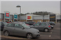
3
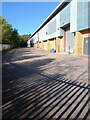
Loading/unloading bays at the rear of retail units
Service bays at the rear of a series of retail units on the Telford Bridge Retail Park.
Image: © Richard Law
Taken: 18 Oct 2022
0.08 miles
5
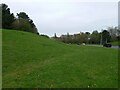
Landscaped pit mound
Much of this area of The Rock is former coal workings; pits, shafts and many spoil heaps are shown on pre-development maps dated in the 1920s. Almost all trace was wiped away in the 1960s & 1970s when Telford Development Corporation undertook a lot of landscaping work, and the area has since been heavily redeveloped for housing, commercial and retail use. A few remnant spoil heaps survive, including the one on the left of this verge, although I suspect its shape may owe more to the bulldozer of the 1970s than the toil of the colliers in the 1890s.
Image: © Richard Law
Taken: 16 Apr 2023
0.10 miles
6

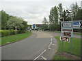
East side of Malinslee roundabout
One of Telford's busier interchanges - it lies close to the retail honeypots of the Town Centre, and handles a lot of traffic to and from the western and southern parts of the town.
Image: © Richard Law
Taken: 25 Nov 2022
0.11 miles
8
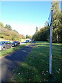
Footway beside Caledonian Way
The footpath runs along the roadside, behind the retail units on the Telford Bridge retail park.
Image: © Richard Law
Taken: 18 Oct 2022
0.11 miles
9
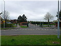
School entrance & exit
Vehicle access route in and out of the Thomas Telford School
Image: © Richard Law
Taken: 16 Apr 2023
0.11 miles