IMAGES TAKEN NEAR TO
Burtondale, TELFORD, TF3 1PW
Introduction
This page details the photographs taken nearby to Burtondale, TF3 1PW by members of the Geograph project.
The Geograph project started in 2005 with the aim of publishing, organising and preserving representative images for every square kilometre of Great Britain, Ireland and the Isle of Man.

There are currently over 7.5m images from over14,400 individuals and you can help contribute to the project by visiting https://www.geograph.org.uk
Image Map
Images are licensed for reuse under creativecommons.org/licenses/by-sa/2.0
Notes
- Clicking on the map will re-center to the selected point.
- The higher the marker number, the further away the image location is from the centre of the postcode.
Image Listing (17 Images Found)
Images are licensed for reuse under creativecommons.org/licenses/by-sa/2.0
Image
Details
Distance
1
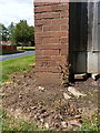
OS benchmark - Brookside, 1 Brereton
An OS cutmark on the end face of a garden wall; originally levelled at 127.06m above Ordnance Datum Newlyn.
Image: © Richard Law
Taken: 15 Aug 2015
0.05 miles
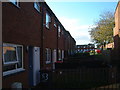
2
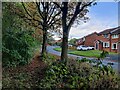
Path next to Cygnet Drive at Brookside, Telford
Image: © Mat Fascione
Taken: 15 Sep 2023
0.06 miles
3
Recreation in Brereton
Another view of the recreation area among the houses... Someone's helpfully painted a goal for the local kids.
Image: © Steve McShane
Taken: 12 Nov 2005
0.10 miles
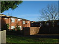
4
Brereton Housing and play area
There used to be a slide here as part of the amusement, but that has probably long since gone. The housing remains though, with one local resident making some improvements at the time of the photograph! Sadly, someone has applied their own message to the L-shaped wall - a sign of the times?
Image: © Steve McShane
Taken: 12 Nov 2005
0.10 miles
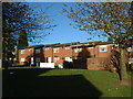
5
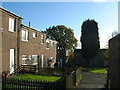
35-38 Brereton
Local council housing, built in the early 1970s.
Image: © Steve McShane
Taken: 12 Nov 2005
0.10 miles
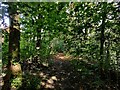
6
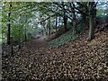
Path and woodland next to the A442 Brockton Way
Image: © Mat Fascione
Taken: 15 Sep 2023
0.12 miles
7
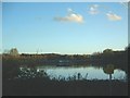
Holmer Lake
The lake is owned by Severn Trent and is mainly used by anglers.
Image: © Steve McShane
Taken: 12 Nov 2005
0.15 miles
8
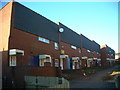
Burtondale Flats
Picturesque 60s/70s council housing in Brookside. The path continues on up toward Brookside Shops.
Image: © Steve McShane
Taken: 12 Nov 2005
0.16 miles
9
Blakemore housing
More council housing...
Image: © Steve McShane
Taken: 12 Nov 2005
0.17 miles
10
Path and woodland alongside the A442 Queensway
Image: © Mat Fascione
Taken: 15 Sep 2023
0.18 miles