IMAGES TAKEN NEAR TO
Piccadilly Close, TELFORD, TF2 9WL
Introduction
This page details the photographs taken nearby to Piccadilly Close, TF2 9WL by members of the Geograph project.
The Geograph project started in 2005 with the aim of publishing, organising and preserving representative images for every square kilometre of Great Britain, Ireland and the Isle of Man.

There are currently over 7.5m images from over14,400 individuals and you can help contribute to the project by visiting https://www.geograph.org.uk
Image Map
Images are licensed for reuse under creativecommons.org/licenses/by-sa/2.0
Notes
- Clicking on the map will re-center to the selected point.
- The higher the marker number, the further away the image location is from the centre of the postcode.
Image Listing (10 Images Found)
Images are licensed for reuse under creativecommons.org/licenses/by-sa/2.0
Image
Details
Distance
2
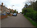
Houses on Waterlow Close
Several houses, and one particularly poor example of on-pavement parking. No consideration for others whatsoever just there.
Image: © Richard Law
Taken: 1 Apr 2024
0.15 miles
3
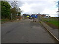
A5 at entrance to Granville Waste management
Image: © John Firth
Taken: 9 Jun 2013
0.19 miles
5
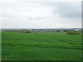
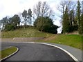
The end of the road - for the moment, anyway
About as far as this spur of York Road goes at the present. Presumably it'll link up with a road, yet to be built, in the housing development to the east.
Image: © Richard Law
Taken: 1 Apr 2024
0.20 miles
6
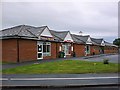
Doctors Surgeries and local shops, East Priorslee
Chip Shop, Convenience store, Hairdressers and Shifnal and Priorslee Medical Practice, all in a purpose-built range of shops in the newest part of Priorslee, east of Castle Farm Way. All this was farm land ten years ago.
Image: © Mike White
Taken: 17 Jul 2008
0.20 miles
7
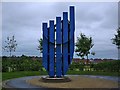
Blue Hand, East Priorslee
The asymmetric location on its 'mini-roundabout' works better than a dead-centre placing would.
The fields surrounding this sculpture are marked Private Land and are intended for further residential development.
Image: © Mike White
Taken: 17 Jul 2008
0.21 miles
8
A5 Eastbound Approaching Entrance to Re-Cycling Centre
Image: © Roy Hughes
Taken: 24 Feb 2014
0.22 miles
9
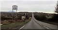
Redhill
Severn Trent Water reservoir compound TUMP.
Name: Redhill
Hill number: 17150
Height: 190m / 623ft
Parent (Ma/M): 2843 The Wrekin
Section: 38A: Shropshire
County/UA: Telford and Wrekin (UA)
County/UA: Shropshire (CoU)
Class: Tump (100-199m)
Grid ref: SJ726109 (est)
Drop: 47m
Col: 143m SJ699102
Image: © Rude Health
Taken: 25 Mar 2015
0.24 miles
10
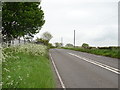
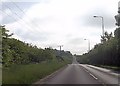
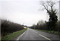
Watling Street (A5)
Looking east on the old Roman Road.
Image: © JThomas
Taken: 18 May 2019
0.25 miles