
IMAGES TAKEN NEAR TO
Hollinswood Road, TELFORD, TF2 9TZ
Introduction
This page details the photographs taken nearby to Hollinswood Road, TF2 9TZ by members of the Geograph project.
The Geograph project started in 2005 with the aim of publishing, organising and preserving representative images for every square kilometre of Great Britain, Ireland and the Isle of Man.

There are currently over 7.5m images from over14,400 individuals and you can help contribute to the project by visiting https://www.geograph.org.uk
Image Map
Images are licensed for reuse under creativecommons.org/licenses/by-sa/2.0
Notes
- Clicking on the map will re-center to the selected point.
- The higher the marker number, the further away the image location is from the centre of the postcode.
Image Listing (46 Images Found)
Images are licensed for reuse under creativecommons.org/licenses/by-sa/2.0
Image
Details
Distance
1
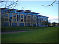
Offices, Central Park estate
The offices of CapGemini Ltd, working with HMRC to keep us all paying tax in a legitimate and equitable manner. When I first moved to the area, what's now known as Central Park housed a 'maggot factory' where we'd buy bait for fishing. It had its own very distinctive smell around here...
Image: © Richard Law
Taken: 8 Jan 2011
0.01 miles
2
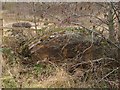
Two Furnace Cores
Here's another furnace core, with Image in the background. I looked for more, but think this is it.
Image: © Mike White
Taken: 12 Mar 2009
0.03 miles
3
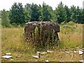
Possible Furnace Core
This block of impure iron more than a metre in each direction and was probably too heavy to be removed from the site. It's the sort of thing that remains if a furnace is put out without allowing the iron to melt and be drawn off. A furnace grown cold in this way has to be broken up because the core can't be removed. I've called it a stone, but it's mostly iron, because a magnet sticks to it. It's a tangible relic of Priorslee Furnaces.
Image: © Mike White
Taken: 24 Jul 2008
0.04 miles
4
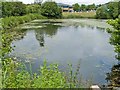
Fishing Pond, Central Park
One of the few local features on the 1889 map that still exist today, it's now a fishing pool instead of a reservoir for the Priorslee Furnaces.
Image: © Mike White
Taken: 25 Jun 2008
0.04 miles
5
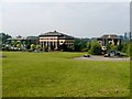
Central Park Offices
Office buildings in Central Park, Telford, where Priorslee Furnaces once stood. L-R: Partnership; Grosvenor; St James'. Telford Town Centre is in the background, Plaza House at extreme right.
Image: © Mike White
Taken: 25 May 2008
0.09 miles
6
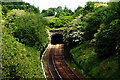
Oakengates Railway Tunnel
The Southern entrance to the Oakengates railway tunnel. Built in the 1840s to Broad Gauge dimensions although Broad Gauge track never reached this far. It is the furthest North of any structure built for Brunel's brainchild. The North end is here-- Image
Image: © Gordon Cragg
Taken: 26 May 2003
0.12 miles
7
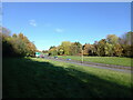
A442 Queensway south of the Greyhound junction
Also known to those of us who've lived locally for a few years as The Eastern Primary (or simply the 'EP'), the road was built as part of the development of Telford New Town to serve as a fast distributor road on the eastern side of Telford.
Image: © Richard Law
Taken: 11 Nov 2023
0.12 miles
8
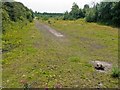
Post-Industrial Landscape
Nature is reclaiming this former railway marshalling yard and industrial site east of the long-gone Priorslee Furnaces. Currently it is used by local youths as a motorcycle track, but will probably be redeveloped for offices.
Image: © Mike White
Taken: 24 Jul 2008
0.13 miles
9
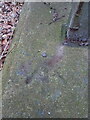
OS rivet - Snedshill, footbridge
An OS rivet benchmark on the concrete base of the footbridge over the A442 Queensway/Eastern Primary road. It was last levelled in 1984 at 141.74m above Ordnance Datum Newlyn.
Image: © Richard Law
Taken: 19 Mar 2023
0.14 miles
10
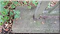
Cinderloo Benchmark
The OS benchmark is positioned into the south-west end of the footbridge that spans the A442 at Ketley Bank, Telford. It is on the north-west side of the footpath. The footbridge sits on the historic route of that taken by the miners, furnace workers and colliers protesting at wage cuts in 1821. The protest would result in the Cinderloo Riots.
Image: © Anthony Rowley
Taken: 16 Oct 2021
0.14 miles