
IMAGES TAKEN NEAR TO
Bryony Way, TELFORD, TF2 9QU
Introduction
This page details the photographs taken nearby to Bryony Way, TF2 9QU by members of the Geograph project.
The Geograph project started in 2005 with the aim of publishing, organising and preserving representative images for every square kilometre of Great Britain, Ireland and the Isle of Man.

There are currently over 7.5m images from over14,400 individuals and you can help contribute to the project by visiting https://www.geograph.org.uk
Image Map
Images are licensed for reuse under creativecommons.org/licenses/by-sa/2.0
Notes
- Clicking on the map will re-center to the selected point.
- The higher the marker number, the further away the image location is from the centre of the postcode.
Image Listing (24 Images Found)
Images are licensed for reuse under creativecommons.org/licenses/by-sa/2.0
Image
Details
Distance
1
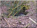
Source of the Wesley Brook
The brook starts at the other end of this culvert, in the dam that holds in Priorslee Flash.
Image: © Mike White
Taken: 12 Mar 2009
0.13 miles
2
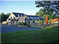
Priorslee, Priorslee
The Priors Lodge, Priorslee, was built in the 1980s on an old pit mound at a reputed cost of £1 million, a fortune at the time. It's had its ups and downs, hence (apparently) the change of name to the Priorslee. New York it isn't, but the garden was full of diners on the evening before this early morning picture was taken.
Image: © Mike White
Taken: 1 Jul 2008
0.14 miles
3
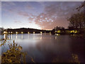
View Across the Flash to the Bridges
A paved path runs round the Flash and passes over two long bridges: Image
Image: © Mike White
Taken: 23 Oct 2019
0.16 miles
4
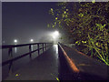
Bridges on the Flash
The wooden bridges were rotting and have been replaced by steel ones with plastic decking.
Image: © Mike White
Taken: 23 Oct 2019
0.16 miles
5
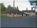
Doctor's Surgery; Dentist's Surgery
The doctor's surgery was located in the old cottage to the right until the new surgery on the left was built. The old surgery was then taken over by a dental practice.
Image: © Mike White
Taken: 30 Jun 2008
0.16 miles
6
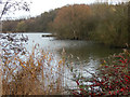
Priorslee Flash
This is the southern end of Priorslee Flash, a substantial lake surrounded by Telford's suburban development.
Image: © Stephen McKay
Taken: 29 Nov 2015
0.16 miles
7
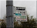
Bus stop in Priorslee
This rather scruffy bus stop flag on Priorslee Avenue is served by Arriva Midlands service 14 which runs between Oakengates and central Telford by a roundabout route. The flag has been covered with a modern sticker but surprisingly a National Bus Company double arrow logo is discernible in the bottom left hand corner. Close inspection suggested that it might once have belonged to United Counties, a company that never operated anywhere near here. This means that the flag must be more than 28 years old.
Image: © Stephen McKay
Taken: 29 Nov 2015
0.17 miles

9
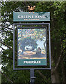
"Priorslee" Pub Sign
What used to be called The Prior's Lodge has been renamed The Priorslee and is now a Greene King "Flaming Grill" with a new sign showing a bucolic scene not too different from the real thing. Here is the pub itself: Image
Image: © Mike White
Taken: 6 Jun 2020
0.18 miles
10
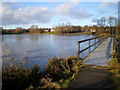
Lakeside path, Priorslee Flash
Here on the NE side of the Flash, the circumnavigatory path runs on a walkway across a shallow section of the lake, rather than being made on the boggy shore.
Image: © Richard Law
Taken: 8 Jan 2011
0.18 miles