IMAGES TAKEN NEAR TO
Priorslee Road, TELFORD, TF2 9EB
Introduction
This page details the photographs taken nearby to Priorslee Road, TF2 9EB by members of the Geograph project.
The Geograph project started in 2005 with the aim of publishing, organising and preserving representative images for every square kilometre of Great Britain, Ireland and the Isle of Man.

There are currently over 7.5m images from over14,400 individuals and you can help contribute to the project by visiting https://www.geograph.org.uk
Image Map
Images are licensed for reuse under creativecommons.org/licenses/by-sa/2.0
Notes
- Clicking on the map will re-center to the selected point.
- The higher the marker number, the further away the image location is from the centre of the postcode.
Image Listing (35 Images Found)
Images are licensed for reuse under creativecommons.org/licenses/by-sa/2.0
Image
Details
Distance
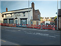
1
Eco Dwellings in old Priorslee
These modern timber-framed houses replace a row of old cottages demolished in 2008. They are being clad in brick and block-work but the structure, including the roof, is entirely supported by the timber frame. They are well insulated and have provision for solar heating built in.
Image: © Mike White
Taken: 13 Jun 2008
0.08 miles
2
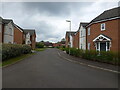
The western part of Raxster Drive
New houses on an estate in Snedshill.
Image: © Richard Law
Taken: 27 Apr 2024
0.09 miles
3
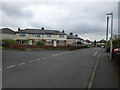
Looking northwest along Freeston Avenue, Snedshill
Image: © Richard Law
Taken: 27 Apr 2024
0.10 miles
4
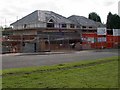
Elephant and Castle St Georges
This pub is now closed but an extension is being added, replacing an earlier single-storey block. It may reopen as a pub but residential use seems more likely.
Image: © Mike White
Taken: 2 Jun 2020
0.10 miles
5
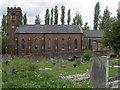
St Peter's Church, Priorslee
St Peter's Church, Church Rd, Priorslee. Built in 1836 from bricks made a few hundred yards west at Snedshill Brick Works. It was built here as a replacement for the old chapel half a mile east in Priorslee village, so as to be nearer the majority of parishioners. The building of thousands of houses east and south of the A5 has left this church as isolated at the westernmost end of Priorslee as its predecessor was to the east.
Image: © Mike White
Taken: 23 Jun 2008
0.11 miles
6
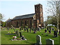
St Peter's Church at Priorslee
This rather fine, Grade II listed https://www.britishlistedbuildings.co.uk/101033297-church-of-st-peter-st-georges-and-priorslee#.WRTNEtQrLGg building was erected in 1836, and listed in 1983.
Image: © Richard Law
Taken: 9 Apr 2017
0.12 miles
7
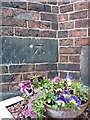
OS benchmark and bolt - Snedshill, St Peter's church
An OS cutmark and bolt from the 1st Primary Levelling of the country between 1840 - 1860; this mark was levelled at 561' 2" above Ordnance Datum Liverpool. It lies on the wall just to the right of the entrance to Image
Image: © Richard Law
Taken: 5 Apr 2014
0.12 miles
8
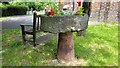
12th Century Font
The 12th Century from Priorslee Chapel that now sits in the grounds of St Peter's Church in Snedshill
Image: © Anthony Rowley
Taken: 23 Jun 2021
0.12 miles
9
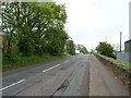
B5061, Telford
Looking south east - towards the A5.
Image: © JThomas
Taken: 18 May 2019
0.14 miles
10
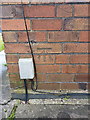
OS benchmark - St George's, 102 Freeston Avenue
An OS cutmark in the brickwork at the side of 102 Freeston Avenue; originally levelled in 1985 at 170.31m above Ordnance Datum Newlyn.
Image: © Richard Law
Taken: 10 May 2014
0.14 miles