IMAGES TAKEN NEAR TO
Ladbrook Drive, TELFORD, TF2 9DL
Introduction
This page details the photographs taken nearby to Ladbrook Drive, TF2 9DL by members of the Geograph project.
The Geograph project started in 2005 with the aim of publishing, organising and preserving representative images for every square kilometre of Great Britain, Ireland and the Isle of Man.

There are currently over 7.5m images from over14,400 individuals and you can help contribute to the project by visiting https://www.geograph.org.uk
Image Map
Images are licensed for reuse under creativecommons.org/licenses/by-sa/2.0
Notes
- Clicking on the map will re-center to the selected point.
- The higher the marker number, the further away the image location is from the centre of the postcode.
Image Listing (21 Images Found)
Images are licensed for reuse under creativecommons.org/licenses/by-sa/2.0
Image
Details
Distance
1
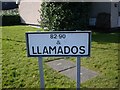
I couldn't resist it.
Perhaps the spelling should be Llamedos?
Image: © Mike White
Taken: 20 Feb 2009
0.03 miles
2
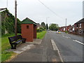
Stafford Street, St George's, Telford
Looking north east.
Image: © JThomas
Taken: 18 May 2019
0.04 miles
3
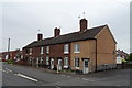
Houses on Stafford Street, St George's, Telford
Image: © JThomas
Taken: 18 May 2019
0.06 miles
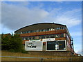
4
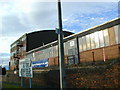
Former metal works at Oakengates
These buildings were revitalised with the development of the New Town of Telford in the 1970s, as workshops and small businesses.
Image: © Bob Bowyer
Taken: 3 Sep 2005
0.09 miles
5
View of part of the Snedshill Trading Estate.
Taken from the Greyhound Roundabout on the old A5, where it bridges the main Eastern Primary route of Telford.
Image: © Bob Bowyer
Taken: 7 Sep 2005
0.09 miles
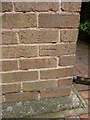
6
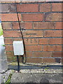
OS benchmark - Snedshill, no 1 Furnace Lane
An OS cutmark in the brickwork at the side of no 1 Furnace Lane; originally levelled in 1985 at 173.277m above Ordnance Datum Newlyn.
Image: © Richard Law
Taken: 10 May 2014
0.12 miles
7
OS benchmark - St George's, 16 The Grove Estate
An OS cutmark at the front of no 16, The Grove; originally levelled in 1985 at 168.506m above Ordnance Datum Newlyn.
Image: © Richard Law
Taken: 10 May 2014
0.16 miles
8
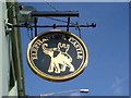
Elephant and Castle pub sign
A bit plain, though gilt.
Image: © Mike White
Taken: 20 Feb 2009
0.16 miles
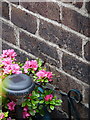
9
OS benchmark - St George's, 102 Freeston Avenue
An OS cutmark in the brickwork at the side of 102 Freeston Avenue; originally levelled in 1985 at 170.31m above Ordnance Datum Newlyn.
Image: © Richard Law
Taken: 10 May 2014
0.17 miles
10
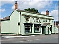
Elephant and Castle, St Georges
Elephant and Castle, Stafford St. One of the few pubs left in St Georges that isn't for sale/to let/closed/demolished, it is clearly being well looked-after, as the smart paint and hanging baskets indicate.
Image: © Mike White
Taken: 11 Jun 2008
0.19 miles