IMAGES TAKEN NEAR TO
Landy Close, TELFORD, TF2 8QL
Introduction
This page details the photographs taken nearby to Landy Close, TF2 8QL by members of the Geograph project.
The Geograph project started in 2005 with the aim of publishing, organising and preserving representative images for every square kilometre of Great Britain, Ireland and the Isle of Man.

There are currently over 7.5m images from over14,400 individuals and you can help contribute to the project by visiting https://www.geograph.org.uk
Image Map
Images are licensed for reuse under creativecommons.org/licenses/by-sa/2.0
Notes
- Clicking on the map will re-center to the selected point.
- The higher the marker number, the further away the image location is from the centre of the postcode.
Image Listing (10 Images Found)
Images are licensed for reuse under creativecommons.org/licenses/by-sa/2.0
Image
Details
Distance
3
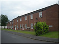
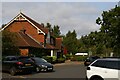
Barratt's Homes, Donnington
A new development of Barratt's Homes at Station Road, Donnington on former Ministry of Defence land. Nice outlook from the front facing properties, a Wyevale Garden Centre and then open countryside for miles.
Image: © Gordon Cragg
Taken: 28 Apr 2009
0.10 miles
6
Back garden on Humber Lane, north of course of former Wellington - Stafford line near Donnington, 1991
[This is a view that was taken by mistake, as it is nowhere near Donnington station, but is perhaps too late to withdraw!] It is NW of the site of Donnington station, which was on the secondary main ex-LNWR line from Stafford to Wellington, which was closed to passengers 7/9/64, to goods 4/10/65. The station site was near the present roundabout on the new A518 by-pass, part of which has been built over the course of the railway. Close by was the Donnington Central Ordnance Depot (COD), to which until 1979 there was rail access from Wellington; in 2010 this line was restored, to serve the new Telford Rail Freight Depot. (See [http://www.telford.org.uk/railway]).
Image: © Ben Brooksbank
Taken: 21 Oct 1991
0.22 miles
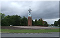
7
C & W Walker's Clock
This clock belonged to the heavy engineering company of C & W Walker and was outside their foundry which was nearby to the present site.
Image: © Mike White
Taken: 28 Jun 2008
0.23 miles
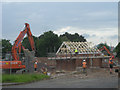
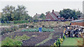
8
Crossroads, The Humbers
A field on the edge of town - how long will it remain a field. Here because of a road closure elsewhere. There is nearly always a road closure.
Image: © Richard Webb
Taken: 8 Dec 2021
0.23 miles
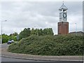
9
The Clock Tower restaurant, Telford
Image: © Christopher Hilton
Taken: 11 Sep 2020
0.24 miles
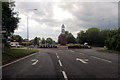
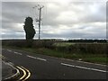
10
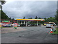
Service station off School Road (A4640)
Near the Clock Tower Roundabout.
Image: © JThomas
Taken: 10 Aug 2019
0.24 miles