IMAGES TAKEN NEAR TO
Turreff Avenue, TELFORD, TF2 8EX
Introduction
This page details the photographs taken nearby to Turreff Avenue, TF2 8EX by members of the Geograph project.
The Geograph project started in 2005 with the aim of publishing, organising and preserving representative images for every square kilometre of Great Britain, Ireland and the Isle of Man.

There are currently over 7.5m images from over14,400 individuals and you can help contribute to the project by visiting https://www.geograph.org.uk
Image Map
Images are licensed for reuse under creativecommons.org/licenses/by-sa/2.0
Notes
- Clicking on the map will re-center to the selected point.
- The higher the marker number, the further away the image location is from the centre of the postcode.
Image Listing (11 Images Found)
Images are licensed for reuse under creativecommons.org/licenses/by-sa/2.0
Image
Details
Distance
1
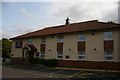
Little Theatre, Donnington
The inscription on the entrance gate reads: DGADOS: Donnington Garrison Amateur Dramatic and Operatic Society. The Little Theatre hosts a thriving and talented amateur group.
Image: © Mike White
Taken: 5 Apr 2009
0.08 miles
2
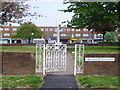
War Memorial at Donnington
War memorial located near a row of shops in Donnington.
Image: © A Holmes
Taken: 29 Apr 2007
0.19 miles
3
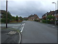
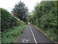
School Road Donnington
Junction with Coronation Drive.
Image: © JThomas
Taken: 10 Aug 2019
0.22 miles
5
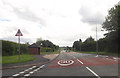
School Road bus stop at Copperfield Drive
Image: © John Firth
Taken: 19 Jun 2012
0.23 miles
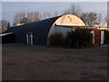
6
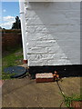
OS benchmark - Donnington, the former Ivy House
An OS cutmark on the wall of the former Ivy House pub, which now operates as the Oasis fish & chip shop. Originally levelled in 1958 at 75.155m above Ordnance Datum Newlyn.
Image: © Richard Law
Taken: 25 Jul 2015
0.23 miles
7
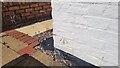
Oasis Fish & Chip Shop Benchmark
The OS cut benchmark is cut into the south facing wall of No.10 Wellington Road. formally known as Ivy House it is now the Oasis Fish & Chip Shop. The benchmark 0.5-metres above ground level and 75.15-metres above the Ordnance Datum Newlyn. It was last verified by the OS in 1958.
Image: © Anthony Rowley
Taken: 7 Sep 2021
0.24 miles
8
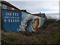
Wall decoration in Muxton
A tiled 'mural' celebrating the flypast in 1986 of the Giotto probe near Halley's Comet.
http://www.sciencedirect.com/science/article/pii/0273117782902939
Image: © Richard Law
Taken: 18 Feb 2012
0.24 miles
9
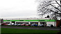
Co-operative Food Store, Donnington, Telford
The Co-operative food store at Wrekin Drive, Donnington, Telford. 8 Dec 2009.
Image: © Gordon Cragg
Taken: 8 Dec 2009
0.25 miles