IMAGES TAKEN NEAR TO
Leonard Close, TELFORD, TF2 8BE
Introduction
This page details the photographs taken nearby to Leonard Close, TF2 8BE by members of the Geograph project.
The Geograph project started in 2005 with the aim of publishing, organising and preserving representative images for every square kilometre of Great Britain, Ireland and the Isle of Man.

There are currently over 7.5m images from over14,400 individuals and you can help contribute to the project by visiting https://www.geograph.org.uk
Image Map
Images are licensed for reuse under creativecommons.org/licenses/by-sa/2.0
Notes
- Clicking on the map will re-center to the selected point.
- The higher the marker number, the further away the image location is from the centre of the postcode.
Image Listing (20 Images Found)
Images are licensed for reuse under creativecommons.org/licenses/by-sa/2.0
Image
Details
Distance
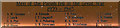
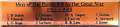
1
Donnington War Memorial WW1
Donnington War Memorial listing of names (M to W) from World War One.
Image: © Gordon Cragg
Taken: 19 Mar 2009
0.12 miles
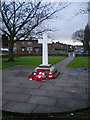
2
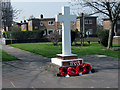
Donnington War Memorial
The War Memorial at Wrekin Drive, Donnington, Telford.
The plaques were originally at another site in the area, Image, but were moved because of vandalism.
Image: © Gordon Cragg
Taken: 19 Mar 2009
0.13 miles
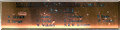
3
Donnington War Memorial WW2
Donnington War Memorial listing of World War Two names.Image
Image: © Gordon Cragg
Taken: 19 Mar 2009
0.13 miles
4
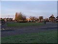
Memorial Garden, Donnington
The garrison town of Donnington is a suitable place for a war memorial: Image The oval garden lies close to the main street, Wrekin Drive. Note the flat-roofed houses behind it.
Image: © Mike White
Taken: 5 Apr 2009
0.13 miles
6
Donnington War Memorial WW1
Donnington War Memorial listing of names from World War One.
Image: © Gordon Cragg
Taken: 19 Mar 2009
0.14 miles
7
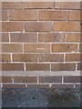
OS benchmark - Donnington, 71 Wrekin Drive
An OS cutmark on the front wall of 71 Wrekin Drive; originally levelled at 82.921m above Ordnance Datum Newlyn.
Image: © Richard Law
Taken: 25 Jul 2015
0.16 miles
8
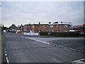
Housing at the junction of West Avenue and Park Road, Donnington
Much of the housing in this part of Telford appears to pre-date the Telford Devt Corporation's work on the town, most of which took place from the late 1960s onwards.
Image: © Richard Law
Taken: 15 Jan 2011
0.16 miles
9
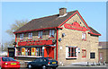
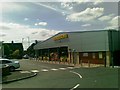
The Champion Jockey, Donnington, Telford
The Champion Jockey pub in March 2003. Named in honour of Sir Gordon Richards, a local lad born in Oakengates. Pub closed 2008 and awaiting redevelopment.Image]
Image: © Gordon Cragg
Taken: Unknown
0.19 miles