IMAGES TAKEN NEAR TO
Millward Close, TELFORD, TF2 8AR
Introduction
This page details the photographs taken nearby to Millward Close, TF2 8AR by members of the Geograph project.
The Geograph project started in 2005 with the aim of publishing, organising and preserving representative images for every square kilometre of Great Britain, Ireland and the Isle of Man.

There are currently over 7.5m images from over14,400 individuals and you can help contribute to the project by visiting https://www.geograph.org.uk
Image Map
Images are licensed for reuse under creativecommons.org/licenses/by-sa/2.0
Notes
- Clicking on the map will re-center to the selected point.
- The higher the marker number, the further away the image location is from the centre of the postcode.
Image Listing (11 Images Found)
Images are licensed for reuse under creativecommons.org/licenses/by-sa/2.0
Image
Details
Distance
1
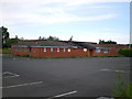
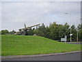
The Coddon Pavilion Sports & Social Club
Or, rather more accurately, the burnt out remains of the place.
Image: © Richard Law
Taken: 1 Jul 2012
0.10 miles
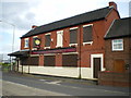
3
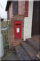
George VI postbox
At the Old Shawbirch public house, Trench Road, Donnington.
Image: © Ian S
Taken: 29 Mar 2016
0.15 miles
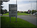
4
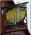
The Old Shawbirch
On Trench Road, Donnington. http://www.geograph.org.uk/photo/4893050
Image: © Ian S
Taken: 29 Mar 2016
0.16 miles
5
The Old Shawbirch
On Trench Road, Donnington. http://www.geograph.org.uk/photo/4893045
Image: © Ian S
Taken: 29 Mar 2016
0.16 miles
7
The Old Shawbirch
On Trench Road, Donnington. http://www.geograph.org.uk/photo/4893050
Image: © Ian S
Taken: 29 Mar 2016
0.16 miles
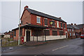
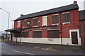
8
The Old Shawbirch pub
On Trench Road in Donnington, and currently boarded up.
Image: © Richard Law
Taken: 1 Jul 2012
0.17 miles
9
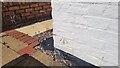
Oasis Fish & Chip Shop Benchmark
The OS cut benchmark is cut into the south facing wall of No.10 Wellington Road. formally known as Ivy House it is now the Oasis Fish & Chip Shop. The benchmark 0.5-metres above ground level and 75.15-metres above the Ordnance Datum Newlyn. It was last verified by the OS in 1958.
Image: © Anthony Rowley
Taken: 7 Sep 2021
0.19 miles
10
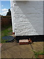
OS benchmark - Donnington, the former Ivy House
An OS cutmark on the wall of the former Ivy House pub, which now operates as the Oasis fish & chip shop. Originally levelled in 1958 at 75.155m above Ordnance Datum Newlyn.
Image: © Richard Law
Taken: 25 Jul 2015
0.19 miles